Kentucky braces for remnants of Hurricane Helene
Republished from WEKU.
Much of Kentucky could feel the impact of the remnants of Hurricane Helene. The storm made landfall in Florida Thursday night and quickly moved through Georgia, Tennessee, and the Carolinas.
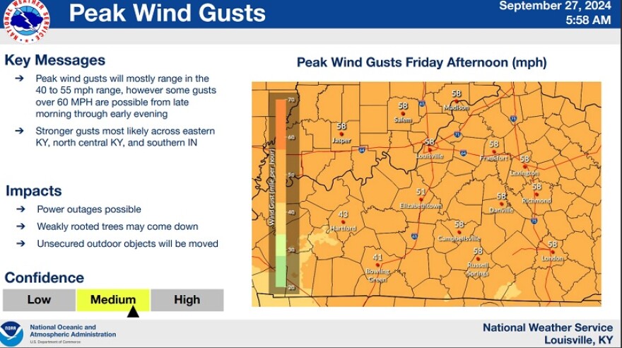
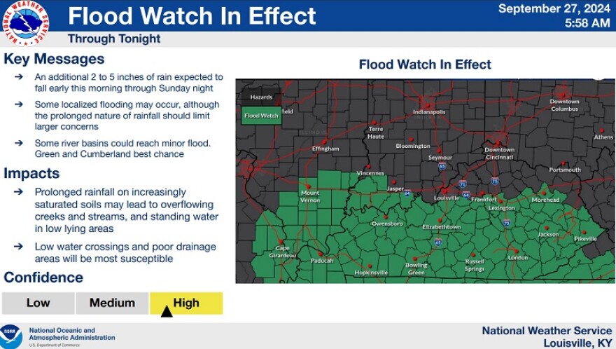
The main concern in Kentucky will be heavy rains and strong wind gusts. Much of southern Kentucky is under a flood watch, this includes areas south and near Interstate-64.
Strong winds and heavy rain is expected in Friday evening, with rain expected to last into the weekend.
The National Weather Service has issued the following warnings:
NWS Louisville
A High Wind Warning is in effect for Pike, Floyd, Knott, Perry, Leslie, Clay, Knox, Laurel, McCreary and Whitley, Bell, Harlan and Letcher counties through 8 PM today.
A High Wind Warning is in effect for Fleming, Montgomery, Bath, Rowan, Estill, Powell, Menifee, Rockcastle, Jackson, Pulaski, Elliott, Morgan, Wolfe, and Lee counties from 10 AM through 8 PM today.
A Wind Advisory is in effect for Wayne, Johnson, Magoffin, Breathitt, Owsley, and Martin from 8 AM EDT through 8 PM today.
Northeasterly to southeasterly winds gusting between 40 to 55 mph; except to between 60 and 70 mph for elevations above 2000 ft and immediately downwind of prominent mountain ranges.
● Gusts to around 60 mph are also possible elsewhere, especially northwest of the white dashed line.
● Saturated soils and unusual wind direction could blow down many trees and power lines.
● Scattered to widespread power outages are expected.
NWS Louisville
● An additional 1 to 3 inches of rainfall is expected through early this evening.
● These amounts of rainfall will be sufficient to cause substantial rises on larger creeks and mainstem rivers.
● Soils in the Upper Cumberland River Basin and South/Middle forks of the Kentucky River are saturated from previous rainfall and this additional rainfall will run off quickly.
● Isolated mudslides will be possible, as well.
** WEKU is working hard to be a leading source for public service, and fact-based journalism. Monthly supporters are the top funding source for this growing nonprofit news organization. Please join others in your community who support WEKU by making your donation.
Originally published by WEKU.
Republished with permission.
https://www.weku.org/the-commonwealth/2024-09-27/kentucky-braces-for-remnants-of-hurricane-helene