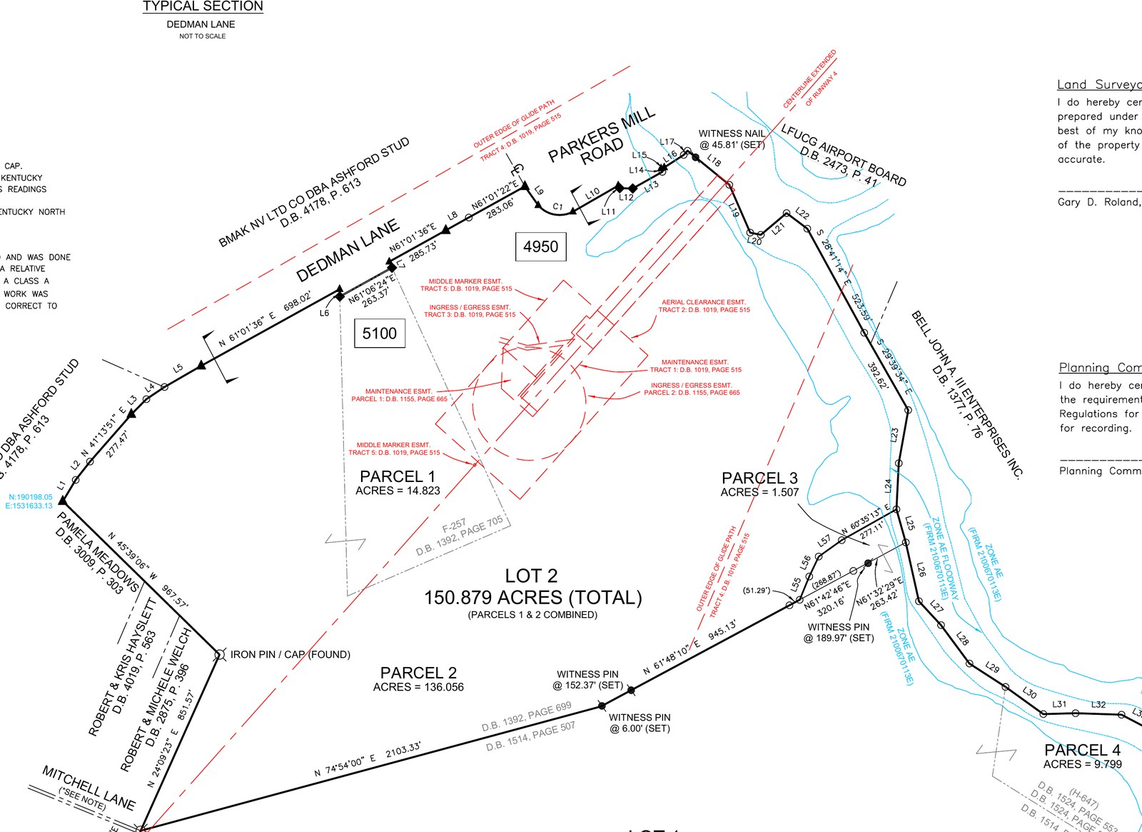
LEXINGTON, Ky. — Shadwell Farm has filed a plat that merges the seven surveyed parcels of its farm on Military Pike, Parkers Mill Road and Dedman Lane into two lots totaling 523.5 acres. The land is the “Shadwell Stallion Complex” that the operation founded by the late Sheikh Hamdan bin Rashid Al Maktoum listed for $20 million in April, and it is bordered by Blue Grass Airport’s land on one side and, across Dedman Lane, by acreage that Coolmore’s Ashford Stud bought from Shadwell in February as part of a roughly 1,100-acre purchase.
The plat does not say why. A consolidation plat is paperwork, not a sale, and no transfer of the four addresses appears in the Fayette County property roll as of June. But it is the kind of paperwork that often precedes a closing. The survey splits the farm along the line that separates the airport side, where the plat records glide-path and marker easements for runway 4, from the Military Pike side, the address the listing carries.
It was a light week otherwise on the city’s Accela Citizen Access portal. The Lexington Times pulled every Planning Division record updated between Sept. 5 and Sunday, 12 records with 16 new attachments, and set aside four zoning-compliance permits. That left eight cases: the Shadwell plat; a plat at a Messer Construction property on West Main Street that maps slivers of land marked with state highway project numbers; a liquor store that wants a pick-up window at the Park Hills Shopping Center on Pimlico Parkway, filed the day after a council committee advanced a rewrite of the city’s drive-through rules; Porter Memorial Baptist Church’s merger of its Nicholasville Road campus with most of the property next door; a pastor’s house at Boone’s Creek Baptist Church; a home barbershop on De Porres Avenue; a short-term rental on a 10-acre Jacks Creek Pike farm; and a lot cleanup at the Meadowthorpe Community Business Center.
Shadwell: two lots, 523 acres, and an airport next door
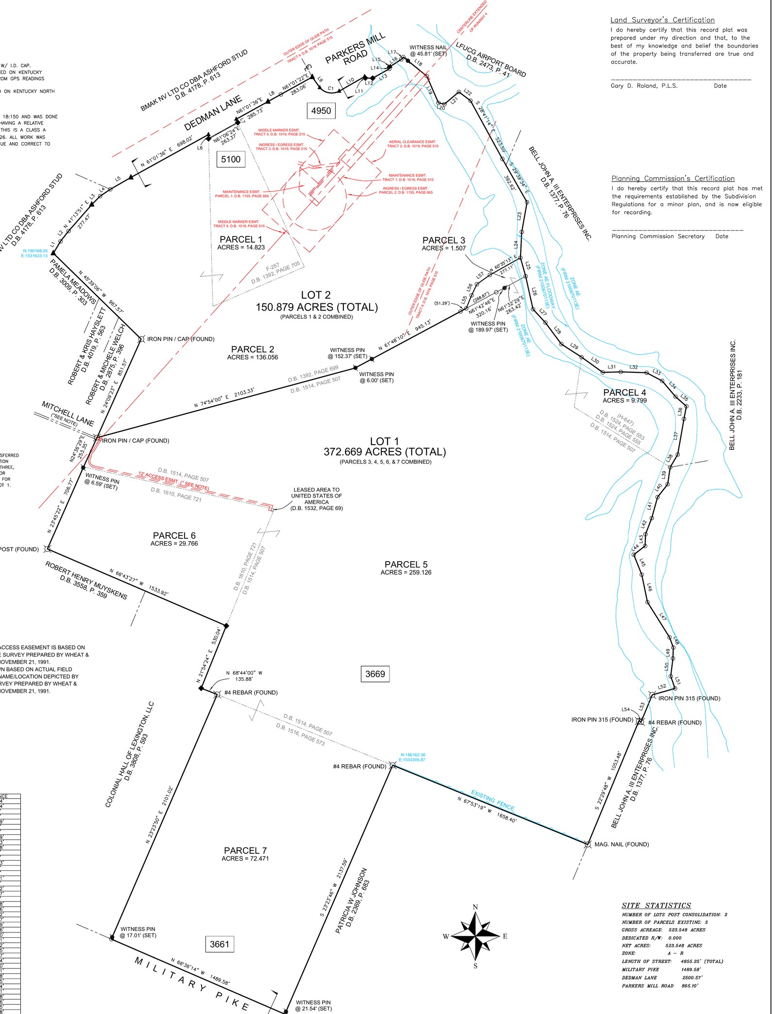
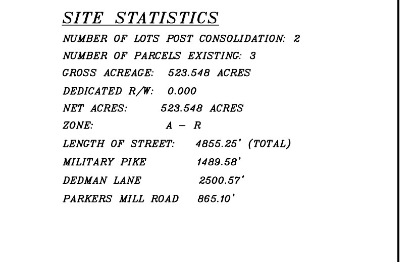
The “Consolidation Minor Subdivision Plat, Shadwell Farms, Inc. Property,” dated September 2026 and prepared by Gary D. Roland of CAM Surveying, was filed on the portal Sept. 8 under record PLN-MNSUB-26-00046 with the status “Payment Received.” It covers 3661 and 3669 Military Pike, 4950 Parkers Mill Road and 5100 Dedman Lane, all zoned Agricultural Rural, in Council District 12. The site statistics list three existing parcels and two lots after consolidation, 523.548 gross acres, no dedicated right of way, and frontage of 1,489.58 feet on Military Pike, 2,500.57 feet on Dedman Lane and 865.10 feet on Parkers Mill Road.
The drawing itself divides the land into seven numbered parcels. Lot 2, at 150.879 acres, combines Parcel 1 (14.823 acres) and Parcel 2 (136.056 acres) along Dedman Lane and Parkers Mill Road. Lot 1, at 372.669 acres, combines Parcels 3 through 7, the largest of which is Parcel 5 at 259.126 acres, and runs south to Military Pike. The two lot figures add to the sheet’s total. A consolidation note says Parcel 1 “shall be sold or transferred only to Parcel 2” and Parcels 3 through 6 only to Parcel 7, standard language that binds the pieces to their new lots.
Lot 2 is the airport side. The plat draws the “outer edge of glide path” and the “centerline extended of runway 4” in red across Parcels 1 and 2 and labels a cluster of recorded easements there: a middle-marker easement, an aerial-clearance easement, maintenance easements and ingress-egress easements, the kind that protect an airport approach. The LFUCG Airport Board’s land adjoins the farm at Parkers Mill Road. Farther south, the plat marks a “leased area to United States of America” where Parcels 5 and 6 meet, without saying what it is.
The northern neighbor across Dedman Lane is listed on the plat as BMAK NV Ltd. Co. doing business as Ashford Stud, Coolmore’s Kentucky farm. The Fayette County Property Valuation Administrator’s roll, as captured in June, shows seven parcels on Fort Springs Pinckard Road, Parkers Mill Road and Military Pike transferred to Ashford Stud on Feb. 25, 2026, each carrying the same $46,517,000 bundle price. Thoroughbred Daily News reported Feb. 27 that Coolmore had bought about 1,100 acres from Shadwell “for close to $50-million, according to a source.”
The four parcels on this plat stayed with Shadwell Farm Inc. in the June roll: 72.5 acres at 3661 Military Pike, 298.76 acres at 3669 Military Pike, 136.856 acres at 4950 Parkers Mill Road and 14.82 acres at 5100 Dedman Lane, bought in 1986 and 1989 and assessed at a combined $14.77 million. Shadwell’s only other Fayette County parcel in the roll is 22.09 acres on Frogtown Lane.
On April 2, Thoroughbred Daily News reported that “the 530-acre Shadwell Stallion Complex has hit the market in Kentucky with a $20-million price tag,” giving its address as 3661 Military Pike and describing a maintenance complex and seven barns with 90 stalls. Six days later the listing agent, Ken Donworth of Bluegrass Sotheby’s International Realty, told the publication “it’s mainly been domestic” and, in the publication’s words, that there are no restrictions on the property, adding, “I feel the Shadwell ownership want to do the right thing and keep it in the equine side of the business.” Sheikh Hamdan died in March 2021; the next year Shadwell listed two other Central Kentucky divisions, on Leestown Road and Frankfort-Georgetown Road.
Whether the plat means one buyer or two, or none yet, is not in the record. A minor plat carries a signature line for the Planning Commission’s secretary rather than a hearing date, and the Accela record carries no letter or description beyond the addresses. Shadwell had not been asked for comment before publication.
West Main Street: slivers of Messer’s corner, marked with state project numbers
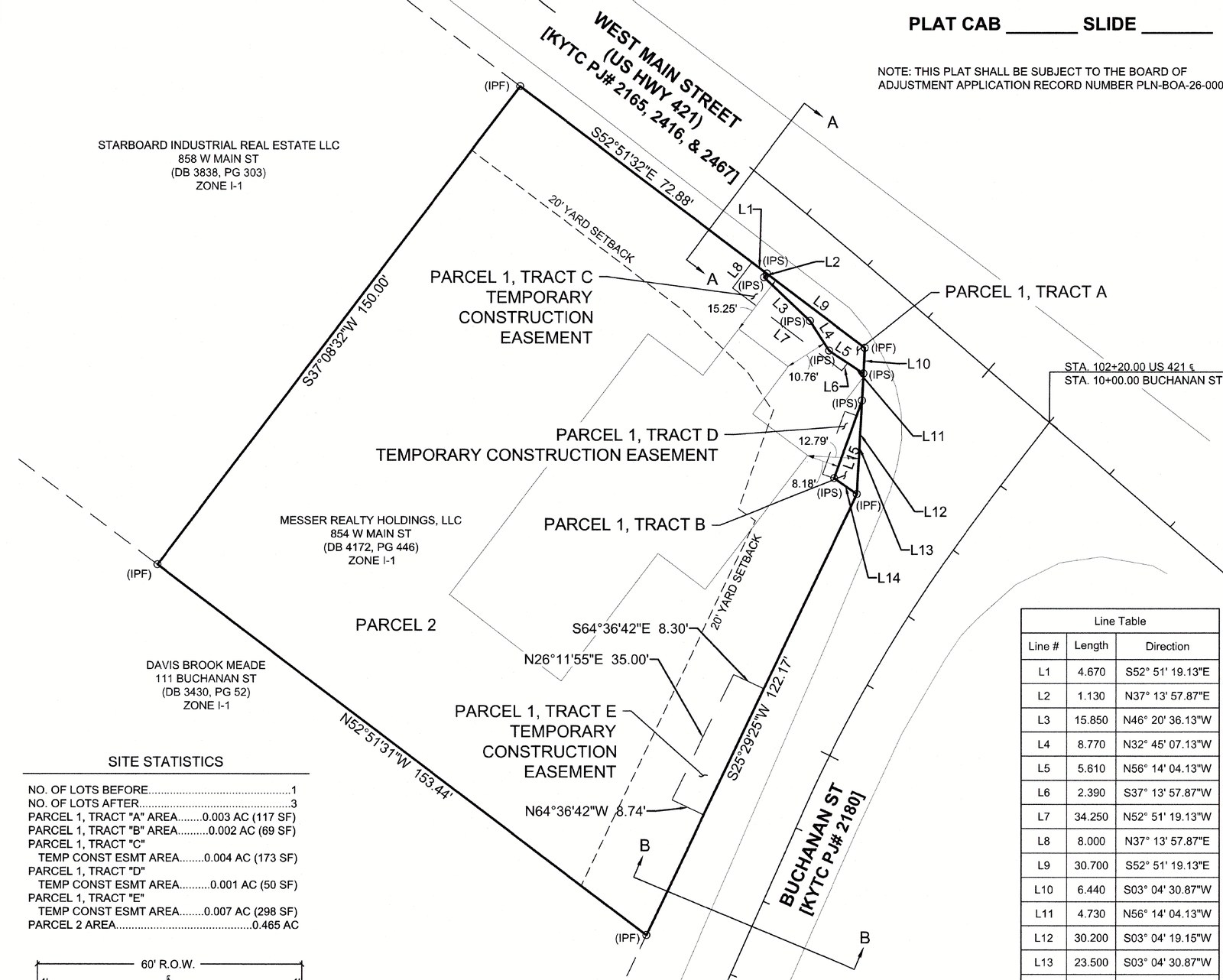
Messer Realty Holdings LLC of Cincinnati filed an “administrative action minor plat” for 854 W. Main St., a lot the Accela record titles “Messer Construction Administrative Action Minor Plat,” signed Sept. 11 by surveyor Joshua S. Calico of Palmer Engineering in Winchester. The Accela description says the plat’s purpose is to “plot the new setback limits from the certificate of land use provided by LFUCG,” and the sheet’s purpose statement says the same. The 0.47-acre lot, zoned I-1 for light industry with a building dated 2002, is listed in the June roll under Messer Realty IX LLC, which bought it in 2012; the plat names Messer Realty Holdings LLC and cites a deed at Book 4172, Page 446.
The drawing shows what moved the setbacks. West Main Street, which carries U.S. 421 at that point, is labeled with Kentucky Transportation Cabinet project numbers 2165, 2416 and 2467, and Buchanan Street with project number 2180. At the corner the plat carves Parcel 1 into five tracts: Tract A, 117 square feet, and Tract B, 69 square feet, plus three temporary construction easements of 173, 50 and 298 square feet. Parcel 2, the 0.465-acre remainder, keeps the building. The site statistics count one lot before and three after. A note says the plat “shall be subject to the Board of Adjustment application record number PLN-BOA-26-00026.” The plat does not name the road project, and the Times could not identify it or find that Board of Adjustment case in the meeting videos available in the archive before publication.

Pimlico Parkway: a liquor store’s pick-up window, and a council rewrite of the drive-through rules
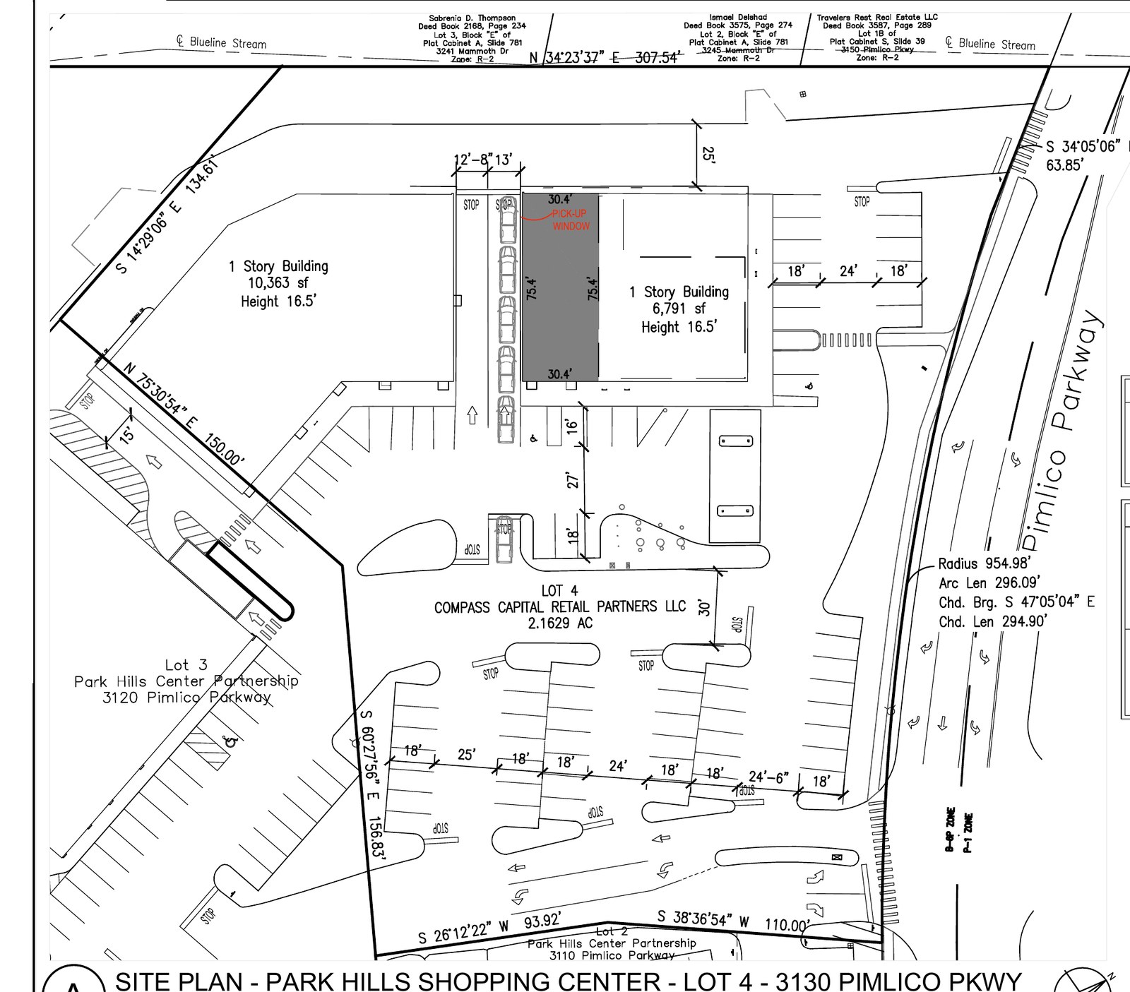
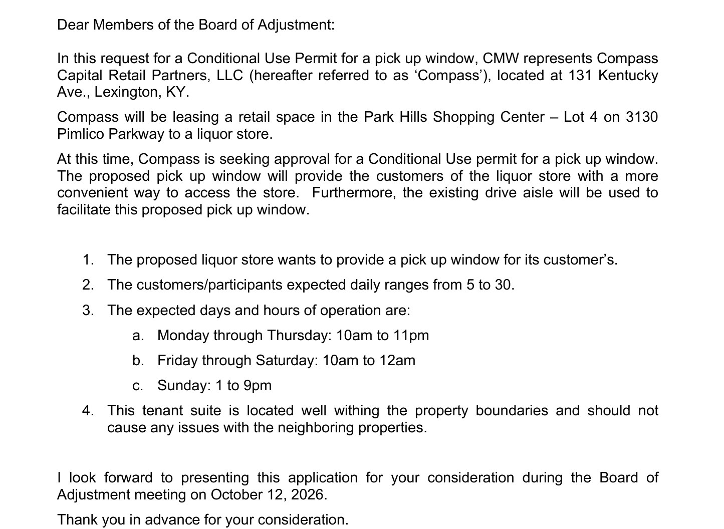
Compass Capital Retail Partners LLC, which bought the 11.16-acre Park Hills Shopping Center parcel at 3120-3130 Pimlico Parkway for $8.4 million in January 2022 according to the June roll, wants a conditional use permit for “a pick-up window for a proposed liquor store within an existing retail space,” according to the Accela record filed Sept. 8. A letter from CMW Inc. dated Sept. 9 says Compass “will be leasing a retail space” to the liquor store, that “the customers/participants expected daily ranges from 5 to 30,” and that the hours would be 10 a.m. to 11 p.m. Monday through Thursday, 10 a.m. to midnight Friday and Saturday and 1 to 9 p.m. Sunday. The site plan puts Lot 4 at 2.163 acres with 73 parking spaces and shows the window on the west wall of a 6,791-square-foot one-story building, served by an existing one-way drive aisle. The shopping center is zoned B-6P, planned shopping center, in Council District 8. CMW’s letter says it expects to present the case at the Board of Adjustment’s Oct. 12 meeting.
Kentucky’s package-license statute lets a store sell spirits and wine “in unbroken packages only, and only for consumption off the licensed premises” and deliver them to customers; it says nothing about windows. The question at the board is a zoning one. The same center was before the city’s Technical Review Committee in November for a drive-through drop-off lane at the Goodwill store on the neighboring lot.
The filing landed one day after the council’s General Government and Planning Committee voted to send a rewrite of the zoning ordinance’s drive-through section to the full council. At the committee’s Sept. 8 meeting, Traci Wade, planning services manager in the Division of Planning, said the existing rule dated to 1983 and required five stacking spaces for every drive-through regardless of use. “We know now 40 years later, that some there drive-thrus maybe need one or two and others might need 20,” she said, according to the meeting’s caption track.
The proposed Section 16-9 separates a “drive-up window,” where customers only pick up goods already ordered, from a “drive-thru facility” with menu boards and order points. A drive-up window would need three stacking spaces and a single lane; a quick-service restaurant would need six for its first lane. Wade said the rewrite “would cover 90% of our drive-thrus and drive-up windows” and that the heaviest users already build more than required. The change grew out of the 2024 state law, House Bill 443, that limited the Planning Commission’s discretion over development plans. Councilmember Whitney Elliott Baxter of District 9, who referred the section to the committee, said it “received a significant amount of feedback from our development community.”
The committee approved the language on Baxter’s motion by voice vote. Before that, committee chair Liz Sheehan of District 5 moved to restore a deleted provision, item c2, that would have required at least one 5-foot pedestrian walkway from the street to the building without crossing a drive-through lane. Wade said attorneys for individual businesses argued the requirement would block drive-throughs on narrow or single-frontage lots. Councilmember James Brown, an at-large member, opposed restoring it: “I think we take a lot of criticism by not being friendly to development.” The amendment failed on a tie vote.
Porter Memorial Baptist Church: the campus and the house next door become one lot
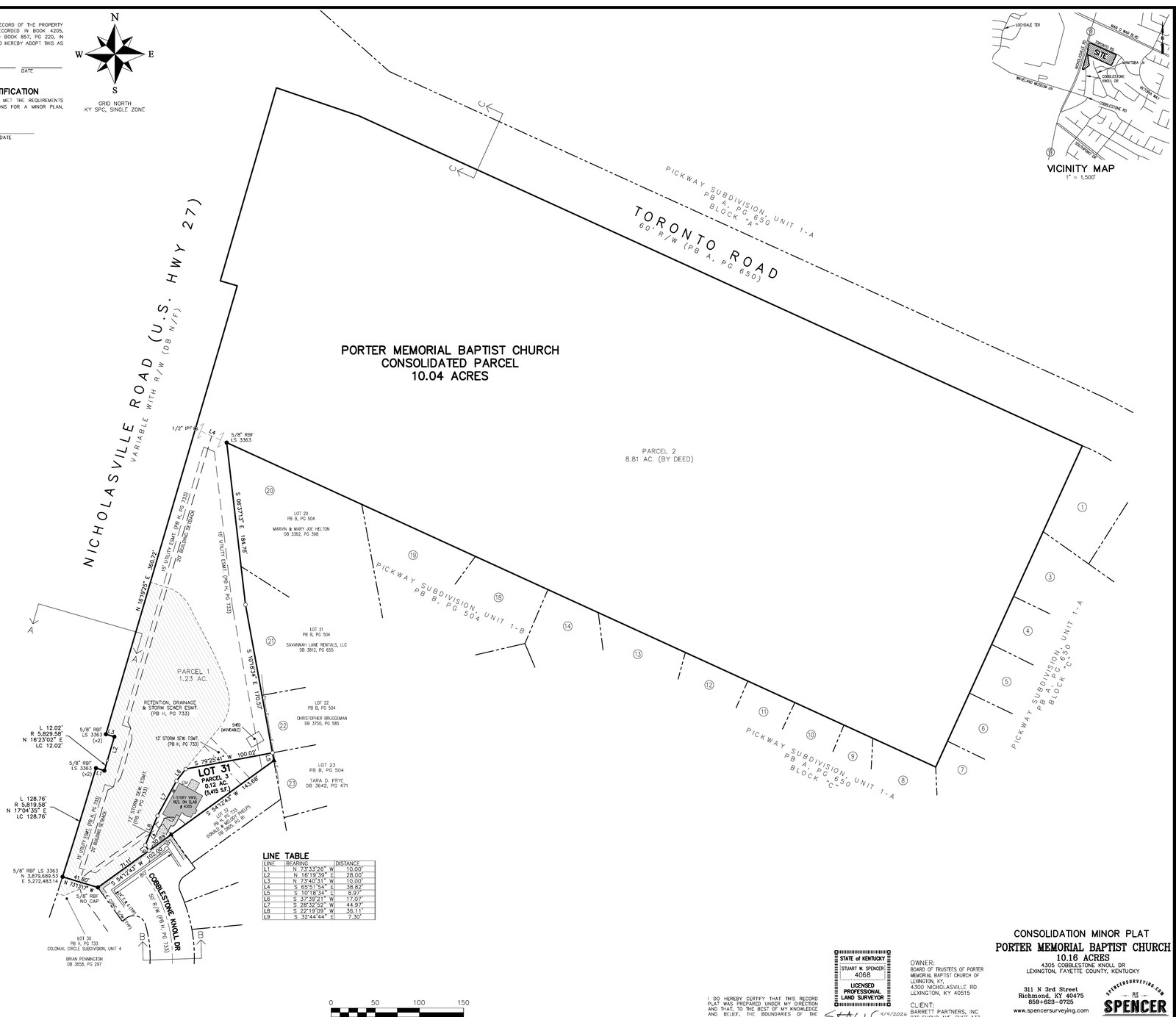
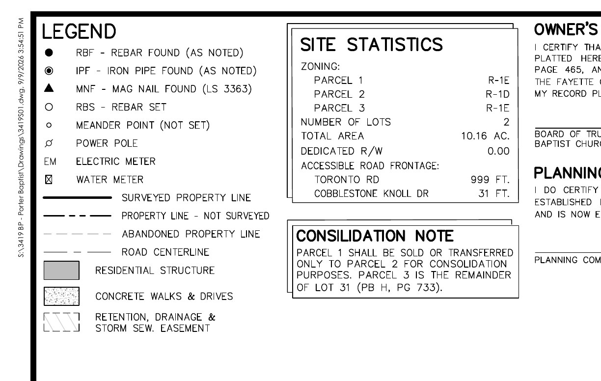
The Board of Trustees of Porter Memorial Baptist Church filed a consolidation plat Sept. 11 that merges its 8.81-acre campus at 4300 Nicholasville Road with 1.23 acres of the property next door at 4305 Cobblestone Knoll Drive into one 10.04-acre parcel. The house itself stays on a separate 0.12-acre lot, the remainder of Lot 31 of the Colonial Circle subdivision. Three lots become two, totaling 10.16 acres. The plat is dated Sept. 9 by Stuart W. Spencer of Spencer Land Surveying in Richmond for a client listed as Barrett Partners Inc. of Lexington.
The church is buying its neighbors. In the June roll the Cobblestone Knoll property, 1.39 acres with a house built in 1990, still belonged to Joseph M. Adams, who paid $205,000 for it in 2023; the plat’s owner certification lists the church as sole owner and cites a deed at Book 4205, Page 465. The roll also shows the trustees paid $232,800 on July 1, 2025, for a fifth of an acre at 4007 Winnipeg Way on the campus’s other side. The church won a conditional use permit from the Board of Adjustment in March 2018 to expand its building and parking lot.
The plat’s access note limits the frontage: “Access to Nicholasville Road is prohibited,” the two larger parcels “access is limited to Toronto Road,” and Parcel 1’s frontage on Cobblestone Knoll Drive “is not accessible due to the retention, drainage and storm sewer easement area.” The sheet gives 999 feet of accessible frontage on Toronto Road and 31 feet on Cobblestone Knoll Drive. No development plan accompanies it. The site is in Council District 4.
Board of Adjustment: a parsonage, a home barbershop and a farmhouse rental
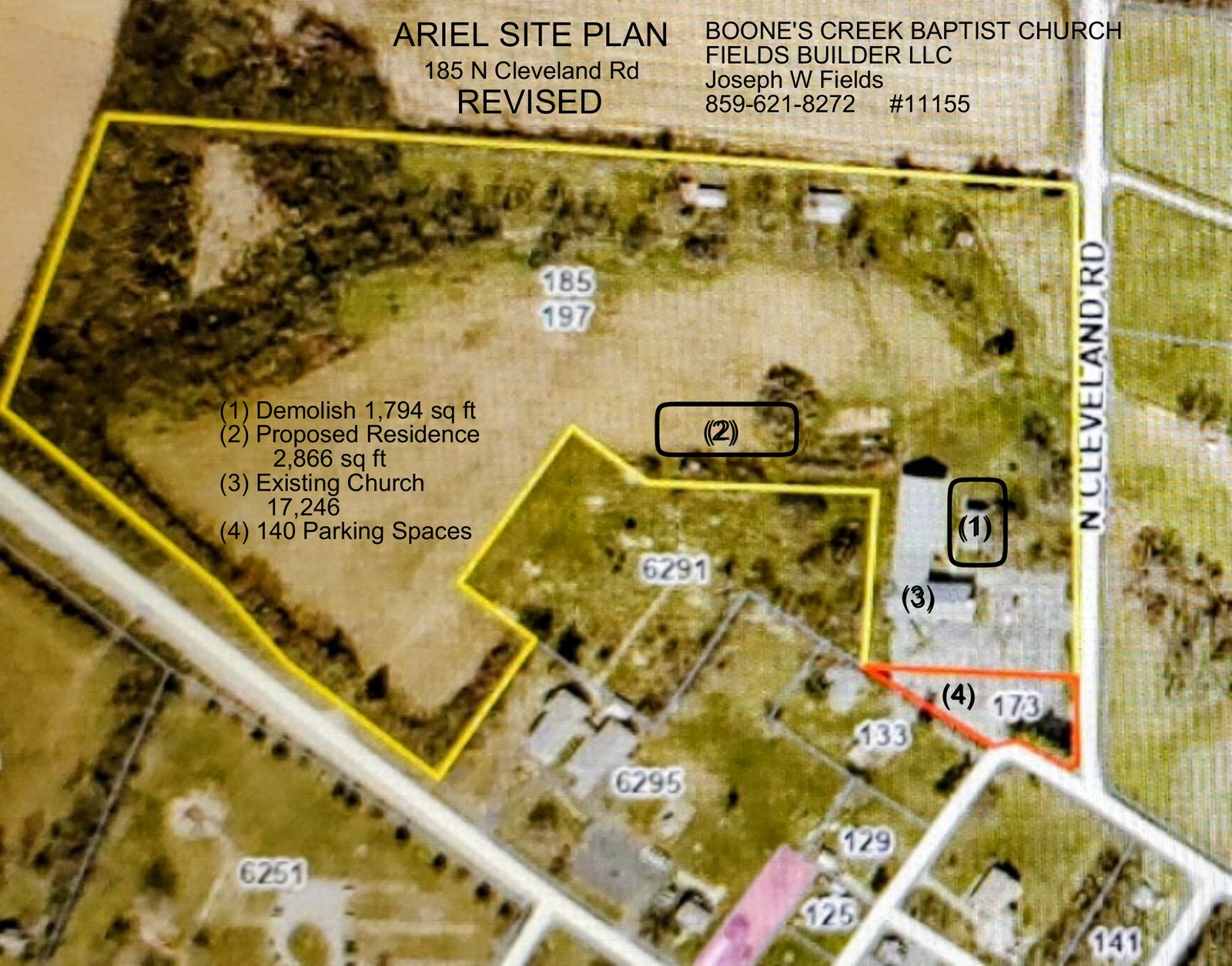
Boone’s Creek Baptist Church, 185 N. Cleveland Road. The church’s first justification statement, dated Sept. 8, asked to convert an existing house on its 22.9-acre Agricultural Rural property into Sunday school rooms for “hopefully 30 children and/or adults” and to build a new residence for the pastor. A revised statement uploaded Sept. 9 drops the classrooms: “We wish to demolish the existing residence and build a new residence for the pastor of the church.” The revised aerial from Fields Builder LLC marks the 1,794-square-foot house to be demolished, a proposed 2,866-square-foot residence, the 17,246-square-foot church and 140 parking spaces. The applicant says the new house, about 45 feet 6 inches by 59 feet, “will be buffered by the church and the mature trees surrounding the property.” The request is filed as a conditional use, the track a church in the Agricultural Rural zone uses for its buildings; Berea Christian Church is on the board’s docket today to amend its own permit for a sanctuary. The site is in Council District 12.
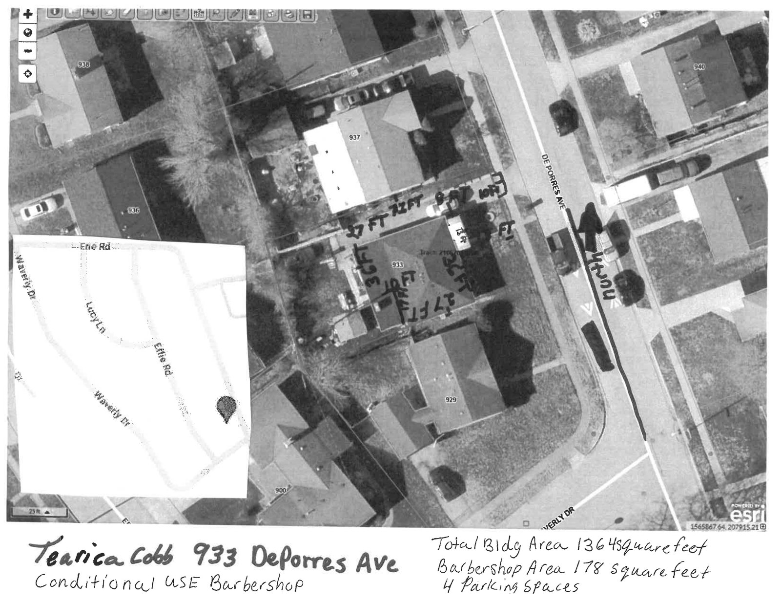
933 De Porres Avenue. An applicant wants to run a barbershop out of 178 square feet of a 1,364-square-foot house on De Porres Avenue in Council District 1, according to a hand-annotated aerial and a four-point justification uploaded Sept. 11. The house, built in 1956 on an eighth of an acre zoned R-1D, is owned by Geraldine Cobb in the June roll; the applicant’s handwritten first name on the sheet was not legible enough to print. The applicant expects seven customers a day, Monday through Saturday from 8 a.m. to 8 p.m., and writes that “the clients will park in my driveway” and that “the music and the tv will be kept to a medium.” The sheet counts four parking spaces.
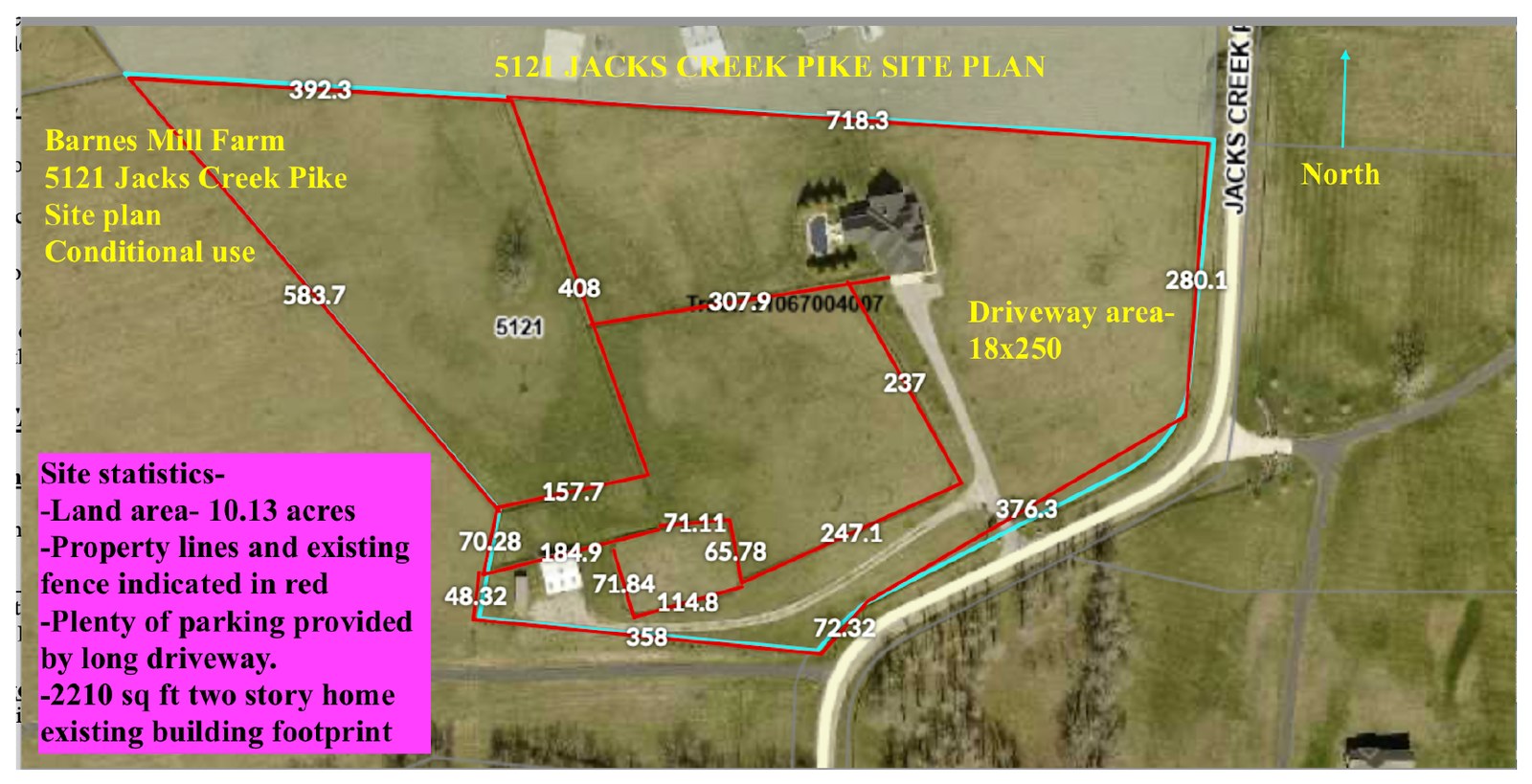
5121 Jacks Creek Pike. A three-page site plan filed Sept. 9 and titled “Barnes Mill Farm” seeks a conditional use for a short-term rental of a 2,210-square-foot two-story house on 10.13 acres in the rural service area, in Council District 12, with “plenty of parking provided by long driveway.” The file name reads “JC STR Site Plan,” and the Accela record carries no description. The June roll lists the owner as Barnes Mill Farm II LLC, which took title April 17, 2026, in a transfer recorded with no sale price; the house was built in 2016 and the property is assessed at $872,500.
None of the three has a hearing date. The Board of Adjustment meets today at 1:30 p.m. on its September docket, which was advertised before these cases were filed; the next meeting is Oct. 12.
Meadowthorpe: a corner to correct
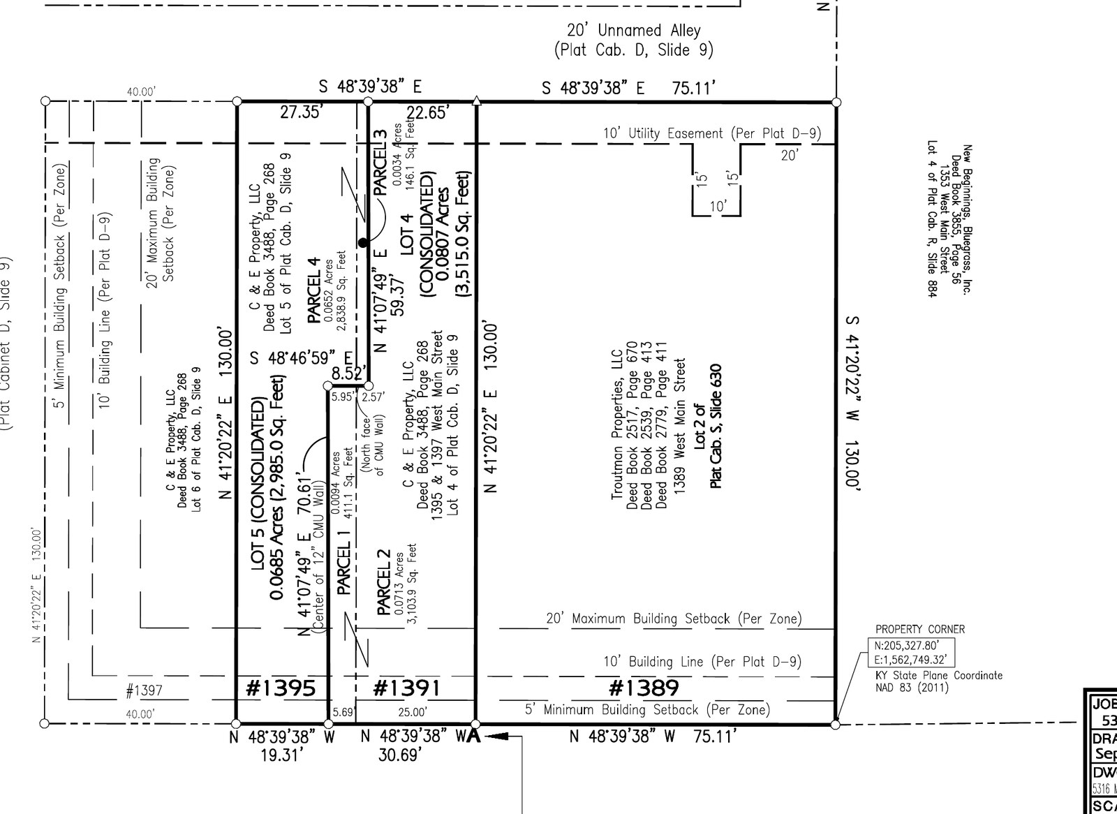
Troutman Properties LLC and C & E Property LLC filed a “corrected amended and consolidation” plat Sept. 8 for three small business lots at 1389, 1391, 1395 and 1397 W. Main St., zoned B-1, totaling 18,264 square feet. Its stated purpose is to consolidate parcels and “correct the coordinates of the southeast corner of Lot 2” from a plat recorded in Plat Cabinet S, Slide 630. Three lots go in and three come out. The plat is a separate filing from the Turner Property 4 rezoning at 1305 through 1309 W. Main St. that is headed to the Planning Commission, though that case’s development plan also carries the business center’s name.
This week and next
At its Sept. 10 subdivision hearing, the Planning Commission postponed the White Farm development plan on Richmond Road and the Griffin Gate Center open-space waiver for a month, approved the Bryant Road substantial-completion waiver with staff conditions, approved Verizon’s temporary 61.75-foot tower at Keeneland and approved a food pantry at Whitney Young Park. It also approved, over one no vote, the open-space waiver for Walmart’s online-pickup addition at 4051 Nicholasville Road, which raised the site’s vegetated open space to 64,000 square feet and its usable open space from 2 percent to 3 percent of the site against a 10 percent standard for each. Commissioner Robin Michler cast the no vote: “We are struggling with the heat island effect of these really vast parking lots. And I appreciate that a tree stand was added. But I don’t think it gets us close enough in my opinion.”
- Monday, Sept. 14, 1:30 p.m. — Board of Adjustment, September docket (Berea Christian Church’s sanctuary, the Harrison Trace driveway variance and others advertised last month).
- Thursday, Sept. 17, 1:30 p.m. — Planning Commission work session; no agenda posted as of Monday morning.
- Wednesday, Sept. 23, 8:30 a.m. — Technical Review Committee.
- Thursday, Sept. 24, 1:30 p.m. — Planning Commission zoning hearing. The agenda was still not posted Monday morning. Expected: Andover Commons, the Ball Homes and OK Gentry expansion-area cases, UP Campus on East High Street, Turner Property 4, the staff industrial text amendment and Goodwill’s donation-center amendment.
- Thursday, Oct. 1 — Subdivision Committee, 8:30 a.m., and Zoning Committee, 1:30 p.m., Phoenix Building.
- Thursday, Oct. 8, 1:30 p.m. — Planning Commission subdivision hearing, where White Farm and Griffin Gate return.
- Monday, Oct. 12, 1:30 p.m. — Board of Adjustment; the Pimlico Parkway pick-up window is the only one of this week’s cases whose paperwork names that date.
- Thursday, Oct. 22, 1:30 p.m. — Planning Commission zoning hearing. The Urban Growth Master Plan implementation amendment filed Aug. 31 still does not appear on the city’s text-amendment page.
How we did this: The Lexington Times scanned the LFUCG Accela portal for every Planning record updated Sept. 5 through Sept. 13, 2026, downloaded the 16 new attachments and read plan sheets from the drawings rather than machine-extracted text. Prior actions were checked against the Granicus meeting archive at meetings.lexingtonky.news; where official minutes are not yet posted, vote counts and quotations are taken from the meeting video and its caption track. Owners of record, acreages, sale dates and prices are from the Fayette Property Valuation Administrator’s roll as captured in June 2026 and were not re-checked against the live roll; zoning and parcel boundaries are from LFUCG’s GIS parcel layer, and council districts from the city’s district boundaries. Sale and listing reports are from Thoroughbred Daily News; the statute quoted is KRS 243.240. Accela status labels (“Payment Received,” “New Document Uploaded From ACA”) are workflow states, not decisions. Each record is linked below.
Sources
- PLN-MNSUB-26-00046 — Shadwell Farms Inc. property consolidation minor plat, 3661 & 3669 Military Pike, 4950 Parkers Mill Rd., 5100 Dedman Ln. (filed Sept. 8)
- PLN-MNSUB-26-00049 — Messer Realty Holdings LLC administrative action minor plat, 854 W. Main St. (uploaded Sept. 11)
- PLN-BOA-26-00082 — Park Hills Shopping Center Lot 4 pick-up window conditional use, 3130 Pimlico Pkwy. (filed Sept. 8)
- PLN-MNSUB-26-00048 — Porter Memorial Baptist Church consolidation minor plat, 4305 Cobblestone Knoll Dr. (uploaded Sept. 11)
- PLN-BOA-26-00081 — Boone’s Creek Baptist Church conditional use, 185 N. Cleveland Rd. (filed Sept. 7; revised Sept. 9)
- PLN-BOA-26-00083 — 933 De Porres Ave. barbershop conditional use (filed Sept. 8)
- PLN-BOA-26-00084 — 5121 Jacks Creek Pike short-term rental conditional use (filed Sept. 9)
- PLN-MNSUB-26-00047 — Meadowthorpe Community Business Center Unit 1 Block D Lots 2, 4 & 5 corrected amended and consolidation plat, 1389–1397 W. Main St. (filed Sept. 8)
- Planning Commission work session, Feb. 19, 2026 — staff briefing on the Urban Growth Master Plan implementation text amendment (about 34 min.)
- Planning Commission Zoning Committee, Sept. 3, 2026 — Regency Holdings Three postponed 4-0; industrial ZOTA approved 4-0; downtown ZOTA postponed 4-0
- Technical Review Committee, Aug. 26, 2026 — Regency Holdings Three development plan (about 2 hr. 1 min.)
- Planning Commission Subdivision Committee, Sept. 3, 2026 — Bryant Road waiver; Griffin Gate waiver postponed
- Planning Commission, Aug. 27, 2026 — Andover Commons, Ball Homes and OK Gentry postponed to Sept. 24
- Planning Commission, Oct. 31, 2024 — Urban Growth Master Plan adopted at continued public hearing
- Planning Commission, Sept. 23, 2010 — Sayre Christian Village zone change (MARC 2010-5) with conditional zoning restrictions
- Urban County Council, Nov. 11, 2010 — second reading, Sayre Christian Village zone change ordinance
- Planning Commission, March 11, 2010 — Sayre Christian Village phased development plan (Phases 1, 2, 3, 4 and 7)
- Planning Commission, Dec. 8, 2016 — Sayre Christian Village Phase 3 amendment (PLN-MJDP-16-00042)
- Planning Commission, Oct. 26, 2023 — accessory dwelling unit text amendment recommended 7-3
- LFUCG current zoning ordinance text amendment applications
- LFUCG Planning Commission — 2026 meeting and filing schedule
- LFUCG Board of Adjustment
- Imagine Lexington — accessory dwelling units
- Imagine Lexington — Urban Growth Master Plan
- Kentucky Secretary of State — business entity search
- ProPublica Nonprofit Explorer — Sayre Christian Village Nursing Home Inc. (EIN 61-0937079)
- The Lexington Times, Aug. 31, 2026 — previous planning-filings roundup
- The Lexington Times, Aug. 24, 2026 — planning-filings roundup (Pasadena Drive drive-through; staff text amendments)
- LFUCG meeting archive
This report was researched and written by AI (Claude Fable 5.1) for The Lexington Times from primary documents: the plats, site plans and letters attached to LFUCG Accela Planning records updated Sept. 5 through Sept. 13, 2026, cross-checked against the Granicus meeting-video archive at meetings.lexingtonky.news, the Fayette PVA roll as captured in June 2026, LFUCG GIS layers, the Kentucky Revised Statutes and Thoroughbred Daily News reports. Plat figures were read from the drawings, not from machine-extracted text. The draft was checked in adversarial verification rounds before publication.
Republishing: This is original Lexington Times reporting, licensed under Creative Commons CC BY-ND 4.0. You may republish this article, in full and unaltered, for free — including commercially — with credit to The Lexington Times and a link to the original.