For my master’s capstone, I wrote a paper on the license plate readers in Lexington. My paper focused on their locations in marginalized neighborhoods as well as privacy concerns with regard to the Fourth Amendment. I wanted to share some key points from my research. The second point is about AI, and I think it’s really important.
Privacy
Mayor Gorton has little regard about privacy concerns. You all should keep this in mind if she runs again. In a press conference in 2022, Chief Weathers was being pressed about the locations of the 25 readers in the pilot program. At the time, they refused to release their locations. This question was posed to Chief Weathers, but Gorton steps in to answer. She condescendingly says, “They’re driving on public roads. It’s very simple. When you’re in the public using public infrastructure, these cameras have every right to be there, and people do not have the right to a particular kind of exemption from the license plate readers because they’re in public right of way.” That video can be watched here.
It’s not “very simple”, however. I am not a lawyer, but there are court cases addressing the issue of privacy and LPRs. In Katz v United States, Justice Stewart wrote that the Fourth Amendment protects people, not places. In Commonwealth v. McCarthy, the court considered if the use of LPRs constituted a search under the Fourth Amendment. In this specific case, a justice wrote: “while the defendant has a constitutionally protected expectation of privacy in the whole of his public movements, an interest which potentially could be implicated by the widespread use of ALPRs, that interest is not invaded by the limited extent and use of ALPR data in this case”. The court also drew upon other cases. I thought these points were particularly important:
“First, unlike one’s movements during a single journey, the whole of one’s movements over the course of a month is not actually exposed to the public because the likelihood anyone will observe all those movements is effectively nil. Second, the whole of one’s movements is not exposed constructively even though each individual movement is exposed, because that whole reveals more — sometimes a great deal more — than does the sum of its parts.”
“ALPRs near constitutionally sensitive locations — the home, a place of worship, etc. — reveal more of an individual’s life and associations than does an ALPR trained on an interstate highway. A network of ALPRs that surveils every residential side street paints a much more nuanced and invasive picture of a driver’s life and public movements than one limited to major highways that open into innumerable possible destinations.”
“Similarly, with cameras in enough locations, the hot list feature could implicate constitutional search protections by invading a reasonable expectation of privacy in one’s real-time location. If deployed widely enough, ALPRs could tell police someone’s precise, real-time location virtually any time the person decided to drive, thus making ALPRs the vehicular equivalent of a cellular telephone ‘ping.’”.
All of that to say, there could be an instance where license plate readers violate the Fourth Amendment.
To read this court case, as well as the court cases it cites, go here.
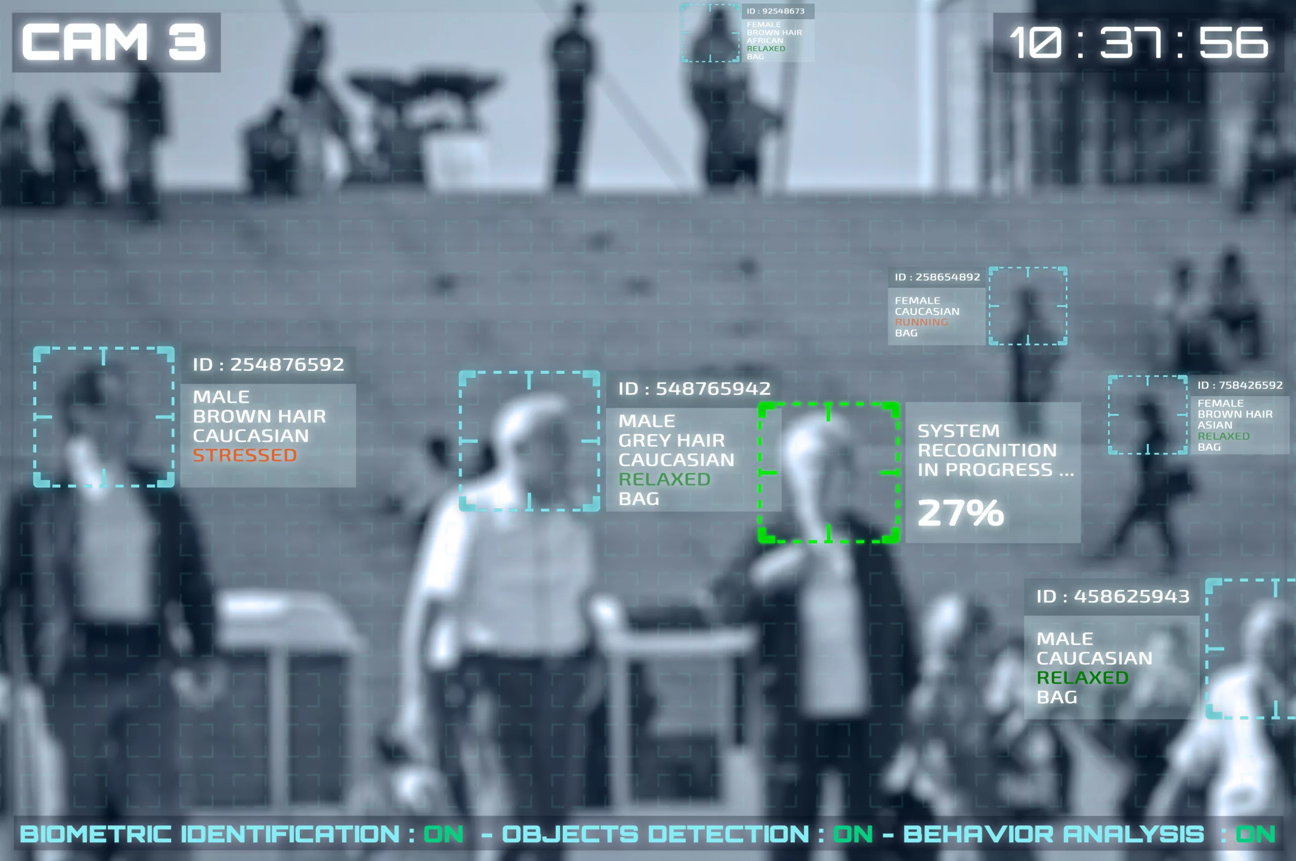
AI and Fusus
In April 2023, Mayor Gorton requested $150,000 for Fusus software. Fusus connects the LPRs and traffic cameras. Private entities can also choose to register their cameras in this centralized network. It’s all monitored at Lexington’s Real-Time Intelligence Center.
What I found particularly concerning in my research were documents from a city council meeting. Go here.
The Purchase of Service Agreement mentions Exhibit A, which is the Service Agreement Proposal. Included in this agreement are five fususCORE Elite AI Appliances.
From the Fusus website: “Fusus AI goes beyond manual search parameters by automating detection capabilities. Fusus AI at the Edge enables users to set alert profiles- when a match to the search parameters appears on any camera in the designated area of interest, alerts are automatically triggered. More here.
To my knowledge, this didn’t have a lot of community input or discussion. Further, I don’t know where these AI devices are located. Finally, you all need to question your city council members as to why they voted yes. There are a lot of ethical implications when it comes to AI and they didn’t really question it. Here were the votes:
The Rushed Vote
Mayor Gorton and Chief Weathers had said the installation of the first 25 cameras were part of a year long pilot program. The first camera was installed in March 2022. The 25th camera was installed in August 2022. Gorton was reelected in November 2022 and hastily made a request to renew the program. It was not yet a year in. My opinion is that this vote was rushed before six new council members could take office. At least two of those members had expressed reservations about the Flock program and a supporter of the program had been voted off council. Personally, I think this was very devious and misleading, as Mayor Gorton had previously stated in a Herald Leader article, “if the year-long pilot project is successful, ultimately the city will have 100 cameras.” She didn’t even give it a year.
From the Flock Agreement with LPD
Some Maps
I used Esri’s US 2023 data to generate these maps. My methodology for creating the maps will be at the end.
Methodology
The license plate reader location data was acquired from The Lexington Times as a GeoJSON file. The demographic data and variables are a part of Esri’s Updated Demographics data. This data is updated annually and includes the current year and five-year forecasts for many demographic categories. In this analysis, the following variables were analyzed:
Included in Esri’s Business Analyst Pro extension are various tools for demographic analysis. “Enrich Layer” and “Generate Standard Geography Trade Areas” are the tools that were used for geoprocessing.
The “Generate Standard Geography Trade Areas” tool was used to generate a polygon feature class of census tracts in Fayette County, KY. Then, the census tracts were enriched with the demographic variable data using the “Enrich Layer” tool. The “Enrich Layer” tool uses data apportionment to “to redistribute demographic, business, economic, and landscape variables to input polygon features.” (https://developers.arcgis.com/rest/geoenrichment/api-reference/data-apportionment.htm). The output feature class with enriched census tracts was used to design the maps in Figures 9-12.
Symbology
Maps were symbolized using graduated colors and the natural breaks (Jenks) classification method. Esri’s documentation defines this classification method as:
“…classes are based on natural groupings inherent in the data. Class breaks are created in a way that best groups similar values together and maximizes the differences between classes. The features are divided into classes whose boundaries are set where there are relatively big differences in the data values.”
ETA: more methodology information as well as another screen capture from the Flock Contract with LPD.
Thu, January 25, 2024
Commentary, Equality, Featured, Local Government
Crystal Harper
For my master’s capstone, I wrote a paper on the license plate readers in Lexington. My paper focused on their locations in marginalized neighborhoods as well as privacy concerns with regard to the Fourth Amendment. I wanted to share some key points from my research. The second point is about AI, and I think it’s really important.
Privacy
Mayor Gorton has little regard about privacy concerns. You all should keep this in mind if she runs again. In a press conference in 2022, Chief Weathers was being pressed about the locations of the 25 readers in the pilot program. At the time, they refused to release their locations. This question was posed to Chief Weathers, but Gorton steps in to answer. She condescendingly says, “They’re driving on public roads. It’s very simple. When you’re in the public using public infrastructure, these cameras have every right to be there, and people do not have the right to a particular kind of exemption from the license plate readers because they’re in public right of way.” That video can be watched here.
It’s not “very simple”, however. I am not a lawyer, but there are court cases addressing the issue of privacy and LPRs. In Katz v United States, Justice Stewart wrote that the Fourth Amendment protects people, not places. In Commonwealth v. McCarthy, the court considered if the use of LPRs constituted a search under the Fourth Amendment. In this specific case, a justice wrote: “while the defendant has a constitutionally protected expectation of privacy in the whole of his public movements, an interest which potentially could be implicated by the widespread use of ALPRs, that interest is not invaded by the limited extent and use of ALPR data in this case”. The court also drew upon other cases. I thought these points were particularly important:
“First, unlike one’s movements during a single journey, the whole of one’s movements over the course of a month is not actually exposed to the public because the likelihood anyone will observe all those movements is effectively nil. Second, the whole of one’s movements is not exposed constructively even though each individual movement is exposed, because that whole reveals more — sometimes a great deal more — than does the sum of its parts.”
“ALPRs near constitutionally sensitive locations — the home, a place of worship, etc. — reveal more of an individual’s life and associations than does an ALPR trained on an interstate highway. A network of ALPRs that surveils every residential side street paints a much more nuanced and invasive picture of a driver’s life and public movements than one limited to major highways that open into innumerable possible destinations.”
“Similarly, with cameras in enough locations, the hot list feature could implicate constitutional search protections by invading a reasonable expectation of privacy in one’s real-time location. If deployed widely enough, ALPRs could tell police someone’s precise, real-time location virtually any time the person decided to drive, thus making ALPRs the vehicular equivalent of a cellular telephone ‘ping.’”.
All of that to say, there could be an instance where license plate readers violate the Fourth Amendment.
To read this court case, as well as the court cases it cites, go here.
AI and Fusus
In April 2023, Mayor Gorton requested $150,000 for Fusus software. Fusus connects the LPRs and traffic cameras. Private entities can also choose to register their cameras in this centralized network. It’s all monitored at Lexington’s Real-Time Intelligence Center.
What I found particularly concerning in my research were documents from a city council meeting. Go here.
The Purchase of Service Agreement mentions Exhibit A, which is the Service Agreement Proposal. Included in this agreement are five fususCORE Elite AI Appliances.
From the Fusus website: “Fusus AI goes beyond manual search parameters by automating detection capabilities. Fusus AI at the Edge enables users to set alert profiles- when a match to the search parameters appears on any camera in the designated area of interest, alerts are automatically triggered. More here.
To my knowledge, this didn’t have a lot of community input or discussion. Further, I don’t know where these AI devices are located. Finally, you all need to question your city council members as to why they voted yes. There are a lot of ethical implications when it comes to AI and they didn’t really question it. Here were the votes:
The Rushed Vote
Mayor Gorton and Chief Weathers had said the installation of the first 25 cameras were part of a year long pilot program. The first camera was installed in March 2022. The 25th camera was installed in August 2022. Gorton was reelected in November 2022 and hastily made a request to renew the program. It was not yet a year in. My opinion is that this vote was rushed before six new council members could take office. At least two of those members had expressed reservations about the Flock program and a supporter of the program had been voted off council. Personally, I think this was very devious and misleading, as Mayor Gorton had previously stated in a Herald Leader article, “if the year-long pilot project is successful, ultimately the city will have 100 cameras.” She didn’t even give it a year.
From the Flock Agreement with LPD
Some Maps
I used Esri’s US 2023 data to generate these maps. My methodology for creating the maps will be at the end.
Methodology
The license plate reader location data was acquired from The Lexington Times as a GeoJSON file. The demographic data and variables are a part of Esri’s Updated Demographics data. This data is updated annually and includes the current year and five-year forecasts for many demographic categories. In this analysis, the following variables were analyzed:
Esri’s methodology for their Updated Demographics is documented here: https://doc.arcgis.com/en/esri-demographics/latest/regional-data/updated-demographics.htm
Specific documentation for the Socioeconomic Status Index is found here: https://storymaps.arcgis.com/stories/6d18af286bd34163aabe5e9c64f66be5
Geoprocessing
Included in Esri’s Business Analyst Pro extension are various tools for demographic analysis. “Enrich Layer” and “Generate Standard Geography Trade Areas” are the tools that were used for geoprocessing.
The “Generate Standard Geography Trade Areas” tool was used to generate a polygon feature class of census tracts in Fayette County, KY. Then, the census tracts were enriched with the demographic variable data using the “Enrich Layer” tool. The “Enrich Layer” tool uses data apportionment to “to redistribute demographic, business, economic, and landscape variables to input polygon features.” (https://developers.arcgis.com/rest/geoenrichment/api-reference/data-apportionment.htm). The output feature class with enriched census tracts was used to design the maps in Figures 9-12.
Symbology
Maps were symbolized using graduated colors and the natural breaks (Jenks) classification method. Esri’s documentation defines this classification method as:
“…classes are based on natural groupings inherent in the data. Class breaks are created in a way that best groups similar values together and maximizes the differences between classes. The features are divided into classes whose boundaries are set where there are relatively big differences in the data values.”
ETA: more methodology information as well as another screen capture from the Flock Contract with LPD.
Crystal Harper
Crystal works in GIS. Her background is in statistics and spatial data science. She is passionate about social justice issues and policy.
Recommended Posts
No need to further victimize children through legislative ineptitude or gubernatorial stubbornness
Fri, July 26, 2024
Andy Beshear sees a path: running through J.D. Vance
Wed, July 24, 2024
Landowners, then and now
Mon, July 22, 2024