🌎 Resumen en español · traducción automática
En 1992, la crecida del arroyo Wolf Run inundó Kilrush Drive en Lexington, destruyendo viviendas durante una tormenta que dejó casi 5 pulgadas de lluvia en un día. En lugar de construir defensas más altas, la ciudad decidió comprar las casas afectadas y permitir que el agua ganara el terreno, transformando la zona en lo que ahora es el bosque de alimentos más grande de Kentucky, donde crecen árboles como pawpaws. Tres décadas después, en 2026, la zona volvió a inundarse cuando cayeron entre 2.5 y 3 pulgadas de lluvia en menos de 90 minutos, recordando que el terreno alrededor de Wolf Run nunca olvida su naturaleza de llanura de inundación.
Traducción y resumen generados por IA a partir del artículo en inglés. Puede contener errores; consulte el texto original.
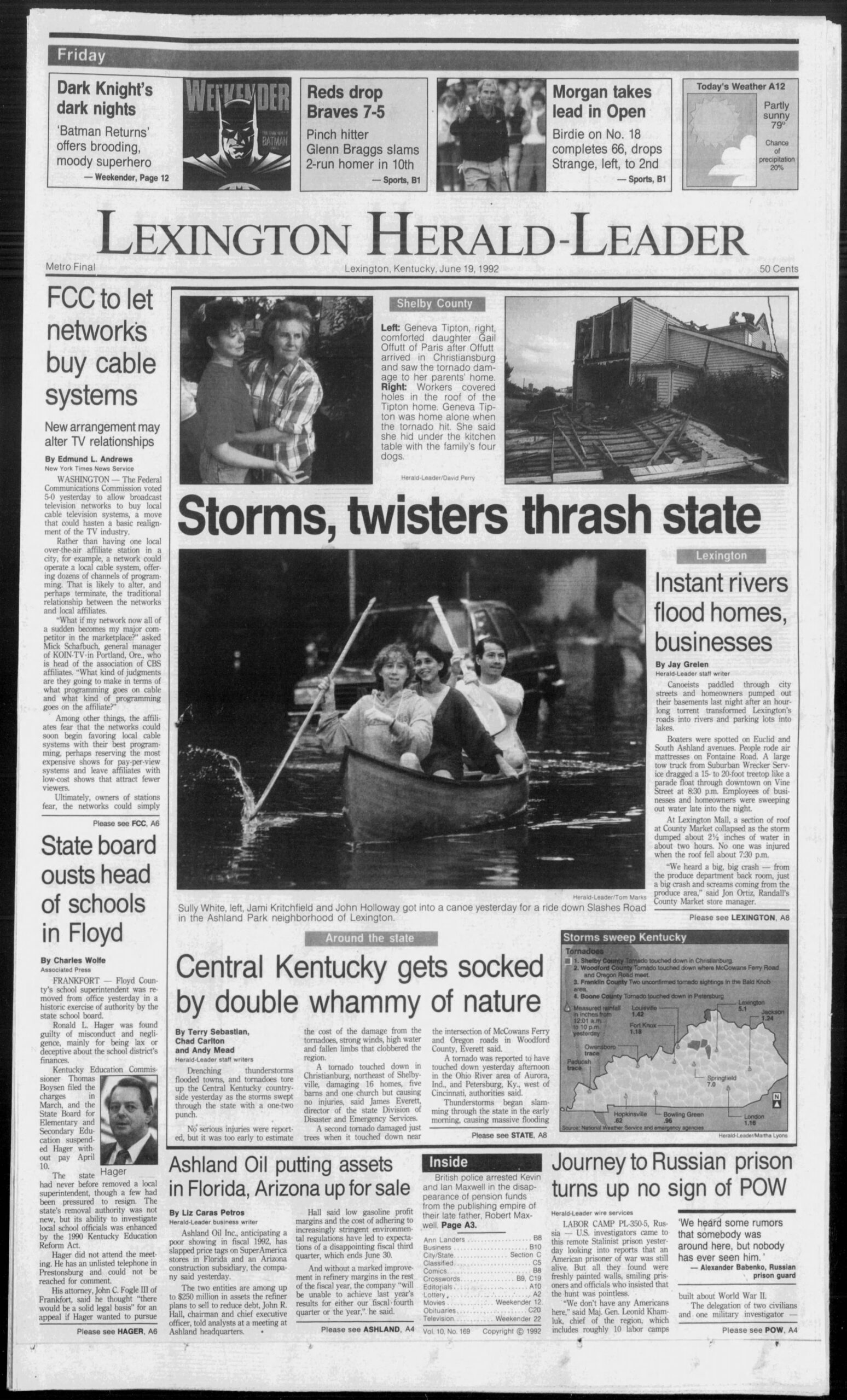
This week in 1992, Wolf Run swallowed Kilrush Drive. The city’s eventual answer wasn’t a taller wall — it was to move the houses out and let the water win. Now that surrendered ground grows pawpaws.
The water came for Kilrush Drive a little after dark.
By 9:30 p.m. on June 18, 1992, Wolf Run had jumped its banks and was pushing into basements along the little west-side street, and residents were being walked out into the rain. By the time the storm passed, inspectors would condemn four duplexes on Kilrush Drive as unfit to live in.
It was one of the worst nights of one of the worst storms the city had seen — 4.99 inches of rain in a single day, just shy of Fayette County’s 24-hour record of 5.88 inches, set in June 1960 — and for a few hours Lexington simply stopped working. Canoeists paddled down Slashes Road in Ashland Park. A tow truck dragged a snapped-off treetop “like a parade float” down Vine Street. The roof over the County Market at Lexington Mall collapsed under standing water around 7:30 p.m. Police and fire took 2,700 calls; the 911 system was “totally inundated,” Police Chief Larry Walsh said, leaving officers talking to dispatch by radio. About 19,000 customers lost power. A BP manager on Richmond Road waded through her own store and reported “Snickers floating out the door.”
This week marks 34 years since that night. Lexington spent part of last week doing the same triage all over again: on June 22, 2026, two and a half to three inches fell in under 90 minutes, stranding cars and forcing water rescues across the city. The ground around Wolf Run does not forget what it is.
The slow surrender
Kilrush Drive sits in the floodplain of Wolf Run, a creek that drains ten square miles of southwest Lexington inside New Circle Road — by the city’s own accounting, one of its most developed, most flood-prone watersheds. For decades the city fought it the way cities used to fight every creek: bigger pipes, detention basins, engineering. By the summer of 2000 it admitted the arithmetic didn’t close.
“Let it flood” is roughly how the Herald-Leader summed up the new strategy in June 2000. Instead of keeping water out of basements, the Urban County Council authorized engineers to appraise 64 flood-prone homes along Wolf Run and its Vaughn Branch tributary, with an eye to buying them out and tearing them down. The city had already bought six homes and four vacant lots the year before. The logic of retreat was blunt: you could spend into the millions on pipes “and we’ll still have floods.”
So that is what happened, lot by lot, through the 2000s. The city’s own Wolf Run Watershed-Based Plan records that “homes have been bought out for floodplain reclamation … in the Kilrush and Deauville areas,” and that the government “recently purchased and demolished numerous flood-prone homes along Wolf Run … in an effort to reclaim a portion of this floodplain.” On the odd-numbered side of the 1100 block of Kilrush Drive — addresses 1103 through 1167 — the houses came down. Today the city’s greenway inventory lists that exact stretch as a single 5.42-acre public greenway named “Kilrush,” in the Wolf Run watershed, maintained by the Division of Environmental Services. Seventeen of the old residential lots now sit on the tax rolls as government-owned and exempt, while most of the homes across the street remain private. A city stormwater official described the parcels plainly at a 2022 meeting: “small lots combined that were bought out from water-quality flood lots — Kilrush, Furlong, Deauville.”
And then, for roughly fifteen years, the city mowed it.
Land that can’t hold houses again
Lexington was doing, in miniature, what the country has been doing at scale. Since 1993, more than 38,000 properties have been bought out and cleared nationwide with FEMA Hazard Mitigation Grant Program money; counting every federal program and pending case, the Natural Resources Defense Council put the figure above 43,000. Where that federal money pays for the buyout, the rule is strict: the home comes down and the land “must be dedicated and maintained in perpetuity as open space.” Lexington bought the Kilrush lots through its own water-quality buyout program rather than with FEMA money, but the end state is the same one the federal rule forces — a permanent public greenway that cannot be built on again.
That rule — 44 CFR 80.19 — is the quiet hinge of this whole story. Buyout land can never hold a walled building or a paved road again. But the same regulation explicitly blesses parks, nature reserves, buffer zones and, in its own words, “cultivation.” Other cities have leaned into that opening: Charlotte has turned 185 acres of bought-out floodplain into greenway; Cedar Rapids bought out 1,356 flood-ruined properties after 2008 and turned part of the cleared land into a 130-acre riverfront greenway; Nashville planted thousands of trees on the homesites it cleared after the 2010 flood. The houses leave; the question of what the empty low ground is for stays behind.
For fifteen years, Lexington’s answer to that question on Kilrush Drive was a lawnmower.
What grows back
The new answer started around 2020, when Nachie Braga and his Lexington company, Geomancer Permaculture, looked at the mowed strip along Wolf Run and saw a forest.
“What you’re standing on is a floodplain,” Braga tells the camera in a year-long documentary of the site. “When the waters rose, all the basements would flood. So maybe 20 years ago, the city and FEMA came through and knocked down all the houses to restore a little bit of the hydrologic function of the floodplain. But then the city’s just been mowing it ever since.” (City records describe the clearance as a stormwater buyout of “water-quality flood lots”; FEMA hazard-mitigation dollars were active elsewhere in the Wolf Run watershed in the same years.)
What Braga proposed was that the city stop mowing and let the floodplain do something other than wait for the next flood. In “one fell swoop,” as he puts it, a single meeting “took this entire greenway out of mowing” — handing the work to the city’s urban-forestry crews so newly planted trees would stop being decapitated by mowing contractors. “Who is managing the public lands is a policy question,” he says, and for once it broke toward planting.
By the end of 2023, more than 100 fruit and nut trees were in the ground along the narrow riparian strip, threaded by footpaths that simply trace the deer trails that were already there, once the invasive Amur honeysuckle was cut back. The roster is deliberately native and edible at once: pawpaw, persimmon, plum, serviceberry, hazelnut, elderberry, chokeberry, bur oak, Catawba grape, and a few experimental American chestnuts that Braga freely admits may not survive the thin, alkaline creek-bottom soil. City urban-forestry crews drop off the trunks of trees felled elsewhere in town — a pin oak from Picadome golf course, for one — and the food forest inoculates the logs with edible mushrooms. “Everything we’re putting back here is food, medicine, all native to North America,” Braga says.
The money has come in small, traceable pieces. The earliest, in 2021, was a $15,355 grant carried on the Water Quality Fees Board’s books under the unimprovable name “Killrush Greenway Stream Buffer Permaculture Food Forest.” In 2024 the council steered $25,000 to Environmental Services and $5,000 to Parks for the project; in 2026 the city’s Environmental Commission landed a $2,000 Fayette County Conservation District grant for it. Geomancer won a state environmental-education award in 2022. Somewhere in there, Braga notes in the video, the work crossed a line: “We have an official budget now, for the first time ever, from the City of Lexington” — after years of grants and volunteer Saturdays. (We told Braga’s own story in The Glaze this spring.)
At roughly three acres of planted ground, it is what Geomancer calls the largest community food forest in Kentucky — a real claim, if a notch below the national benchmarks in Atlanta and Seattle. More to the point, it is public. The greenway belongs to the city; anyone can walk in.
Three lives of low ground
Trace it end to end and the same creek bottom has had three uses in a single lifetime: a place people tried to live, a place the city paid to empty, and a place that now feeds people on purpose. The flood that drove out the first is the through-line to the third — the houses were never coming back, the floodplain and the city’s permanent greenway saw to that, so the only real question was whether the cleared ground would be mowed grass or something that gives back.
The June 22 rains restated the stakes for the thousands of people still living elsewhere in the Wolf Run floodplain, on ground that floods exactly as Kilrush Drive once did. Lexington has not solved that. But on three acres along the creek, it has at least answered the question the water keeps asking — once you admit some land was never meant to hold houses, what is it for?
For now, the answer is hazelnuts.
Reporting for this piece draws on Lexington Herald-Leader coverage of the June 1992 flood and the June 2000 floodplain-buyout policy (via Newspapers.com); LFUCG’s Wolf Run Watershed-Based Plan, Hazard Mitigation Plan, public greenway GIS inventory, and meeting record; and Geomancer Permaculture’s own video documentation of the Kilrush Food Forest. The June 19, 1992 front page above is reproduced as a historical artifact under fair use. The searchable LFUCG meeting record lives at meetings.lexingtonky.news.
Sources
- Lexington Herald-Leader, “Instant rivers flood homes, businesses” / “Storm clogged sewers, 911 lines” (June 19–20, 1992), via Newspapers.com
- “City might buy and raze more houses in flood areas,” Lexington Herald-Leader, June 21, 2000, via Newspapers.com
- LFUCG Wolf Run Watershed-Based Plan (2013)
- LFUCG Hazard Mitigation Plan (2020)
- LFUCG public greenway GIS inventory — “Kilrush,” 1103–1167 Kilrush Dr (5.42 ac, Wolf Run)
- Stormwater Stakeholder Advisory Committee, Sept. 9, 2022 (clip 6536) — “bought out from water-quality flood lots, Kilrush”
- Water Quality Fees Board, July 8, 2021 — $15,355 “Killrush Greenway Stream Buffer Permaculture Food Forest” (clip 5399)
- Urban County Council, Oct. 10, 2024 — $25K to Environmental Services + $5K to Parks for Kilrush (clip 6246)
- Council Work Session, June 2, 2026 — $2,000 Fayette County Conservation District grant (clip 6788)
- “Building the Largest Community Food Forest in Kentucky” — Geomancer Permaculture (YouTube)
- Cardinal Valley grows new beginnings in the Kilrush Food Forest (LEX18)
- FEMA floodplain-buyout open-space rule — 44 CFR 80.19
- Natural Resources Defense Council, “Going Under” (2019)
- The Glaze: Nachie Braga (The Lexington Times)
This feature was drafted with AI assistance (Claude Opus 4.8) and reported and finalized for publication by The Lexington Times. It draws on contemporaneous Lexington Herald-Leader reporting on the June 1992 flood (June 19–20, 1992) and the June 2000 floodplain-buyout policy (June 21, 2000), accessed via Newspapers.com; LFUCG’s Wolf Run Watershed-Based Plan (2013), Hazard Mitigation Plan (2020), public greenway GIS inventory, and council/board meeting record; Geomancer Permaculture’s video documentation of the Kilrush Food Forest (quotations transcribed from its captions); LEX18; and federal floodplain-buyout regulation (44 CFR Part 80). The land link — that the food forest occupies former bought-out, demolished flood lots assembled into the city’s Kilrush greenway — is established at the assemblage level from the city’s GIS, watershed plan, and meeting testimony, not parcel-by-parcel. The June 19, 1992 front-page image is reproduced as a historical artifact under fair use.
Republishing: This is original Lexington Times reporting, licensed under Creative Commons CC BY-ND 4.0. You may republish this article, in full and unaltered, for free — including commercially — with credit to The Lexington Times and a link to the original.