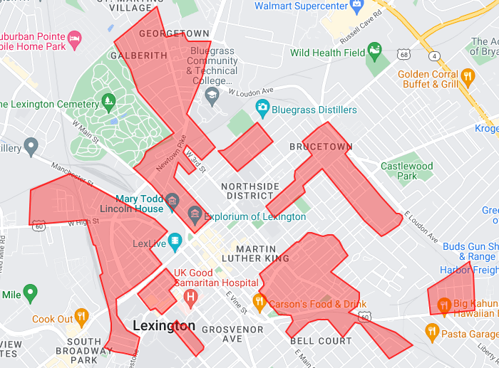
Lexington, Ky 1940 Redlining Map
In the United States, redlining is a discriminatory practice in which services (financial and otherwise) are withheld from potential customers who reside in neighborhoods classified as ‘hazardous’ to investment; these neighborhoods have significant numbers of racial and ethnic minorities, and low-income residents. Redlining was/is practiced in Lexington.
We’ve created an interactive map of Lexington’s redlined neighborhoods, superimposed over a modern day map. The map is based on a 1940 redlining map used by Lexington lenders. The neighborhoods considered “best,” like the newly built Chevy Chase, were rated “A,” “still desirable” areas were rated “B,” and so on, down to the “D” neighborhoods. “D” neighborhoods were considered “hazardous” by the classification system and bankers did not issue loans for homes in those areas. These areas are denoted by red polygons on the map.

Problem viewing the map? Click here to view the stand alone version.
Coordinates sourced from: https://dsl.richmond.edu/panorama/redlining/#loc=14/38.044/-84.506&city=lexington-ky

Recommended Posts
Kamala Harris needs a VP candidate. Could a governor fit the bill?
Fri, July 26, 2024

After cyber-attack on Jefferson County Clerk, Fayette counterpart discusses precautions
Fri, July 26, 2024

An eastern Kentucky animal shelter is swelling this summer
Fri, July 26, 2024