From Slavery to Segregation, From Segregation to Redlining and Gentrification
When examining the stories of historical black settlements in Lexington, there tends to be an emphasis on rural settlements over urban ones. This is often because of the proximity of these rural settlements to visually appealing landscapes and horse farms, which has made them more easily romanticized in the popular imagination. Civic influencers often shy away from discussing their urban counterparts, though, as they highlight our city’s problematic history of slavery, segregation, redlining, urban disinvestment, and gentrification.
The historical urban settlements are equally important to understanding the history of black communities in Lexington. These urban settlements were located on the poorest land and the most unattractive sites in the city, often in poorly drained areas or adjacent to railroad tracks, cemeteries, stockyards, or packinghouses. Consequently, they highlight the city’s problems with poverty, discrimination, and segregation, making them less appealing for popular examination. However, it is crucial to study these historical urban settlements to gain a more comprehensive understanding of the experiences of their residents–past and present–and to recognize the systemic inequalities that have shaped their lives.
Residents stand on their porches as floodwaters rise around homes behind the W.L. Petty Company on Chair Avenue in 1932. (Special Collections, University of Kentucky.) Colorized by The Lexington Times
If every satisfied citizen will take a walk in Davis Bottom or Goodloetown, on Spiegels Hill or Brucetown, he will be more ready to stand back of the Board of Health in its work. Its responsibility is not for individual families, or for property owners, but for the good of the whole community, for the sake of every growing child, for Lexington as a city of healthful homes.
The undesirable lots that freed slaves settled in after the Civil War were frequently in poorly drained bottomlands. An early 1800s Lexington medical report by a prominent physician cited stagnant water as being the cause of “intermittents” in bottomland residents, referring to the intermittent fever associated with a malaria infection.
Living in bottomlands or poorly drained areas was “universally feared” in the nineteenth century, according to scholar Thomas D. Clark, as stagnant water was believed to be responsible for a number of diseases, principally malaria, or “swamp fever. A 1922 real estate tract advertising the new Castlewood neighborhood testifies to the tenacity of this belief. In extolling the virtues of a new subdivision’s “upland” location, the promoters assure prospective buyers, “Your health is not endangered here by low, damp land.” Indeed, a 1924 housing survey called some conditions in Lexington’s low-lying areas “unfit for human habitation”.
Redlined by banks in the twentieth century, these undesirable and disease prone housing tracts would be home to Lexington’s poorest residents for years to come. Redlining is a discriminatory practice in which loans and other services, financial or otherwise, are withheld from potential customers who reside in neighborhoods classified as “hazardous” to investment; these neighborhoods have significant numbers of racial and ethnic minorities, and low-income residents.
With the rise of public transportation in the early 1900s, and the automobile in the mid-1900s, more and more whites moved from urban areas to the suburbs. Government disinvestment in Lexington’s urban centers led to crumbling infrastructure in these communities for many years, only improving with gentrification, a form of urban reinvestment that can displace long term residents while enriching private investors.
1940 Home Owners Loan Corporation Redlining Map of Lexington overlayed onto a modern day map of the city. (Source)
From integration to segregation
The emergence of racially segregated black communities in Southern cities during the early decades following the Civil War replaced the antebellum pattern of integration. Central Kentucky’s history is such a noteworthy example of the mechanisms that led to the formation and placement of these newly-formed clusters of black populations that academic John Kellogg used it as a case study in his 1982 essay, The Formation of Black Residential Areas in Lexington, Kentucky, 1865-1887.
According to Kellogg, demographic change, social attitudes, and land-rent topography were the three factors that governed the development of these neighborhoods. The timing and proportion of black population increase, social attitudes towards black people, and efficient mass transportation systems were all determinants of the broad patterns of residential land use in the nineteenth and early-twentieth-century city. In Lexington, this resulted in the formation of different historic black hamlets throughout the city. The essay examines the unique historical and social contexts that led to the formation of these neighborhoods and highlight their significance in Lexington’s history.
Shotgun homes on unidentified street, ca 1931 from “First Comprehensive Plan of Lexington and Its Environs.” (Lexington Public Library) Colorized by The Lexington Times
In the late 19th and early 20th centuries, large black residential concentrations formed in northern cities, particularly in the last decade of the 19th century and the first decade of the 20th century, Kellogg writes. The Great Migration of southern blacks to the North increased the black population in northern cities, exacerbating racist animosities. During this time, larger northern cities had efficient mass transportation, allowing upper and upper-middle-class whites to move to suburban areas. The residential structure of the city approximated the concentric ring pattern, with the wealthy living on the urban periphery and the poor residing in the central city. Black ghettoes formed in decaying inner-city tenement districts and grew outward through the invasion and succession of older European immigrant housing. Demographic changes, rising racist animosities, and the geographic context of the modern city structure wrought changes in racial residential patterns.
Kellogg explains that the formation of black residential clusters in southern cities followed a similar pattern to that of northern cities. The influx of freed slaves to southern cities after the Civil War occurred during a time of social and political change, leading to increased racial residential separation. The demographic changes and social attitudes in the South from 1865 to 1885 were similar to those in the North from the 1890s to the 1910s.
Railroad workers in Lexington, ca 1897. Lyle Family Photographic Collection, Special Collections, University of Kentucky. Colorized by The Lexington Times
Kellogg discusses the formation of black residential concentrations in southern cities after the Civil War, which occurred during a time of enforced social and political change. The emergence of urban enclaves in the South took place in the context of the preindustrial, pedestrian city, while northern ghetto development took place in the setting of the industrial or modern city.
Kellogg focuses on Lexington as a case study to describe the early mechanisms of inception and growth and to define the social and physical characteristics of black residential concentrations in southern cities. He notes that although Kentucky was generally considered a border state, it was distinctly southern in terms of racial composition, antebellum extent of slaveholding, and racist attitudes of the white population toward black people and their place in society.
Pre Civil War
A highly consulted 1855 Lexington city map. Originally surveyed and published by Hart & Mapother (Source)
Kellogg uses three sources to gain some insight into the antebellum pattern of black residential location in Lexington: the 1860 United States census, an 1867 city directory, and a detailed and highly reliable 1855 map of Lexington, which shows the size and shape of all buildings in the city. The essay also discusses the growth of black communities in border cities, which formed a distinct transitional stage in terms of the timing and magnitude of in-migration and community formation.
In the early 1860s, the pattern that emerges is one of general dispersion of black families throughout the city, with several enclaves of free blacks existing within this pattern. These enclaves were usually located in areas with poor residential site qualities. Non-enslaved black people who did not live in enclaves or the central business area were intermixed with the white population, residing on virtually every street in the city. Slaves who were “living out” (not living with their owners) likely had a similar pattern of residential locations to freedmen, with a larger percentage of them living in enclaves.
Lexington, Ky Free Black Property Ownership, 1860 Source: The Formation of Black Residential Areas in Lexington, Kentucky, 1865-1887 Author(s): John Kellogg The Journal of Southern History, Vol. 48, No. 1 (Feb., 1982), pp. 21-52
Kellogg describes the residential patterns of black people in antebellum Lexington, including free-black enclaves, live-in slave residences, dispersed housing, and barracks for slave workers. Live-in slaves mainly lived in the house with their owners. Black families, both free and enslaved, lived in every section of the city by the end of the Civil War and there were no sizable black residential areas. Residential segregation, if present, was on a very small scale.
Post Civil War
A black union soldier poses with his family. More than 24,000 black Kentuckians served in the Civil War, representing nearly one-third of the Union soldiers from the state. (The Davis Bottom History Preservation Project) Colorized by The Lexington Times
During and after the Civil War, large numbers of freedmen moved from the countryside to the cities and towns of the South. This migration was due to greater educational and employment opportunities, the presence of Federal army garrisons and Freedmen’s Bureau offices, and racist violence by hostile rural whites. Lexington’s black population increased by 133% between 1860 and 1870, with many freedmen coming to the town seeking education and freedom. However, these newly arrived refugees from the rural South were destitute, and many were homeless and without any means of support.
Eight soldiers armed with rifles standing in front of house, undated. Federal troops offered protection to free blacks after the Civil War, while their recruiting stations offered opportunity. University of Kentucky Special Collections Research Center. Colorized by The Lexington Times
Accordingly, there was an increase in demand for inexpensive housing as poor black families moved to cities and towns seeking better opportunities. As Kellogg explains, the demand was met by subdividing estates and farms on the city’s periphery into narrow lots and selling them to homeseekers. However, most black migrants settled in urban clusters, which were located in the interiors of blocks, requiring the construction of new streets or alleys for housing frontage.
Many black enclaves were located on subdivided lots, which necessitated the construction of new side streets and alleys. (Ruger, A. & Ehrgott & Krebs Lith. (1871) Bird’s eye view of the city of Lexington, Fayette County, Kentucky)
Kellogg’s study reveals the residential pattern of the pedestrian city in Lexington during the late 1880s. The pattern shows the concentration of the highest quality housing in the central city, surrounding the central business area, with poorer quality housing situated on the outskirts of the city. The pattern is describable by a distance-decay function, with an inner elite living in the central city and progressively poorer folk living towards the city periphery. The study also identifies three other functions that explain the residential structure of 1886 Lexington, superimposed upon the dominant concentric pattern.
Lexington Housing Quality Map, 1886. Darker color indicates high quality housing. (Kellogg)
WPA photograph of DeRoode Street in Davis Bottom, 1940. Special Collections, University of Kentucky. Colorized by The Lexington Times.
Kellogg describes the three mediating functions that modify the ideal concentric pattern of the pedestrian city in Lexington. The first function is the propensity of the wealthy to reside along important avenues, while the second function involves institutional amenity/non-amenity that resulted in better residences clustering around universities, academies, parks, and churches. The third function is relative elevation, where people preferred to live on higher ground to avoid flooded basements and disease.
Lexington’s Historical Black Urban Enclaves
Kellogg identifies ten urban enclaves that existed in Lexington in 1887.
The housing project originally consisted of 963 units on 82 acres bordered by Withrow Way, Race, Magnolia, Shropshire and Sixth streets.
Around 1990 the Lexington Housing Authority began to thin out the neighborhood by demolishing 295 units. In October 2005 they received a federal grant to demolish the remainder of the structures.
The housing project site was then redeveloped with single family homes, apartments and the addition of William Wells Brown elementary school.
Deweese Street, ca 1931 (Comprehensive Plan of Lexington, Kentucky & Environs) Colorized by The Lexington Times Today, the area of Goodloetown is a predominantly black neighborhood partially shielded from view by Thoroughbred Park in downtown Lexington. (Google)
Kinkeadtown
Modern day East End, Chestnut Street area.
A bottomland subdivision created by George B. Kinkead in 1870.
Purchased exclusively by black residents, and by 1880, approximately 20 families had made their homes there.
Home to Dr. Zirl Palmer’s historic pharmacy. Palmer purchased the property on the southeast corner of 5th Street and Chestnut Street, where he established “Palmer’s Pharmacy, Luncheonette, and Doctor’s Office” in 1961.
After a Ku Klux Klan bombing destroyed Palmer’s other pharmacy, the Palmer Pharmacy Building at 400 East 5th Street is the last building remaining that he built, owned, and managed.
The two black pharmacists who preceded Dr. Palmer in Lexington were Dr. William H. Ballard, opening his business in 1893, and Dr. Harriett B. Marble.
Appeared in Jet magazine, December 14, 1961 Colorized by The Lexington TimesDr. Palmer’s Pharmacy after being bombed at West End Plaza (Bluegrass Trust for Historic Preservation) Colorized by The Lexington Times
Brucetown
Bounded by modern day North Limestone, Broadway, Loudon, and 7th.
An urban cluster in the northeast part of the city created in 1865 by W.W. Bruce, a prominent Lexingtonian and hemp manufacturer.
In a low field across from railroad tracks adjacent to Bruce’s hemp factory.
In 1878, a white mob killed three black men in Brucetown.
Has faced challenges associated with gentrification in recent years.
A 1907 Sanborn Fire Insurance map depicts Brucetown. Greyline Station is currently located near the site of the railway building at top right. (North Limestone Cultural Plan)A 1907 Sanborn Fire Insurance map depicts the area adjacent to Brucetown. Both areas were redlined on the 1940 HOLC redlining map. (North Limestone Cultural Plan)
Pralltown
Modern day Colfax, Montmullin, and Prall Streets, across from UK.
Pralltown was initially located on bottomland that was prone to flooding and hemmed in by railroad tracks.
Named after lawyer John A. Prall.
Created in stages between 1868 and 1877.
In recent years, residents have been in an ongoing battle to prevent the neighborhood from becoming a new housing area for University of Kentucky students.
Photos of Pralltown, ca 1972-1975. Pralltown Development Study, Lexington-Fayette Urban County Government, University of Kentucky Colorized by The Lexington TimesPRALLTOWN: IN LEXINGTON, KENTUCKY Source: D.G. Beers & Co. Atlas of Bourbon, Clark, Fayette, Jessamine and Woodford Counties, Ky. Philadelphia, 1877. Map. https://www.loc.gov/item/2005627107/.
Lee’s Row
Modern day Speigle Heights, near the Versailles Road Viaduct.
Located in the bottom of a steep valley alongside railroad tracks.
By 1880, contained 45 black households.
Lee’s Row, modern day Speigle Heights. (Google)
Davis Bottom
Modern day Oliver Lewis Way/Davis Park.
Located in the bottom of a steep valley alongside railroad tracks.
By 1880, contained 30 black households.
White families, especially immigrants, started to move into the area in the early 1900s, making up 50% of the population by the 1950s.
https://lexingtonky.news/wp-content/uploads/2023/04/DavisBottomTimelapse.mp4A timelapse of aerial photographs shows Davis Bottom from 1993 – 2022. The neighborhood was bulldozed in 2015 to make room for Oliver Lewis Way. (Photos: Fayette PVA)The Demus kids and friends in front of the Davis Bottom park during one of the popular summer softball games, ca. 1990s. (The Davis Bottom History Preservation Project, Demus Family Photographic Collection)
Adamstown
Was located on Adams Street, near modern day Euclid Avenue.
Laid out at the base of a hill on the edge of the city in the 1870s.
Housed 65 black families by 1880.
The neighborhood was removed in preparation for the building of the University of Kentucky’s Memorial Coliseum in 1949-1950.
Adamstown, undated. The neighborhood was removed in 1949 to accommodate the construction of Memorial Coliseum. Louis Edward Nollau F Series Photographic Print Collection, University of Kentucky Special Collections Research Center. Colorized by The Lexington TimesAdamstown (red area), as drawn on a 1940 HOLC redlining map, overlayed over a modern day map.
Taylortown
Bounded by Jefferson, Second, Third, and Georgetown Streets.
Initially settled in the late 1860s.
Expanded to encompass lots on Margaret Wickliffe Preston’s property.
Preston was the widow of William Preston. In 1889, two years after her husband’s death, Preston sold lots at the front of her property.
Margaret Wickliffe Preston (1885-1964) divided her property and sold lots in Taylortown. (Preston-Johnston family photographs, UK Libraries Special Collections Research Center) Colorized by The Lexington Times
Smithtown
Bordered by North Broadway, West Fourth, Jefferson, and West Sixth Streets.
Initially settled in the early 1870s; Expanded in 1888.
Has experienced reinvestment and gentrification in recent years, with new upscale businesses moving into the area.
Located west of town, present day South Broadway near Lower Street, by the railroad overpass and Country Boy Brewing.
Adjacent to Davis Bottom.
Classified as a black cluster by Kellogg, but its history is different from those of the other clusters.
The section of the cluster located closest to the center of town was platted in 1844, but almost all the lots had remained unsold up through the Civil War.
The least expensive of these lots were quickly taken up by black households either during, or more likely, in the two years immediately following the Civil War.
Although the land had been subdivided more than twenty years before it was settled, the area’s site (abutting a railroad), situation (on the city periphery), and time of settlement (the early postbellum period) all conform to the pattern of black urban cluster.
Lower Street, modern day. (Google)
A new day?
The history of Lexington’s urban enclaves is a complex and multifaceted one. While these neighborhoods have faced numerous challenges over the years, including discrimination, neglect, and economic struggles, they have also been places of resilience, community, and cultural richness. By acknowledging the importance of these settlements and recognizing the contributions that they have made to the city’s history, we can better understand Lexington as a whole.
Council Member Tayna Fogle speaks at a press conference at the historic Palmer Building in Kinkeadtown on February 15, 2023. According to the city, the space “will go from an abandoned building to a busy community hub, with nonprofit partners”. (LexTV)
It is crucial that we continue to learn from the past in order to build a brighter future for all members of the community. By wisely investing in these historic neighborhoods and working to preserve their unique heritage, we can create a more inclusive and equitable city that honors its past while embracing its future. Ultimately, it is up to all of us to ensure that these vital pieces of Lexington’s history are not forgotten, but rather celebrated and cherished for generations to come.
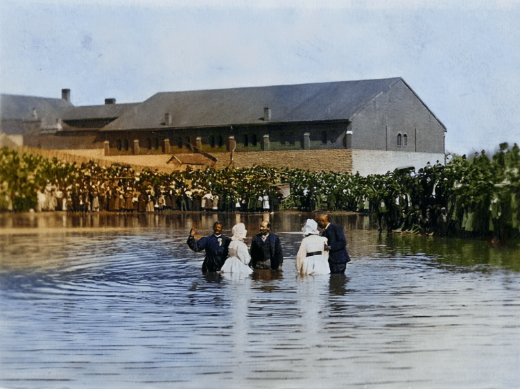
Top photo: “Black baptism at work house pond,” near Davis Bottom with clergy from Pleasant Green Missionary Baptist Church, ca 1898. Bullock Photographic Collection, Transylvania University Library. Colorized by The Lexington Times.
Thu, April 6, 2023
Commentary, Featured, Lexington History
Lexington Times Web Editor
From Slavery to Segregation, From Segregation to Redlining and Gentrification
When examining the stories of historical black settlements in Lexington, there tends to be an emphasis on rural settlements over urban ones. This is often because of the proximity of these rural settlements to visually appealing landscapes and horse farms, which has made them more easily romanticized in the popular imagination. Civic influencers often shy away from discussing their urban counterparts, though, as they highlight our city’s problematic history of slavery, segregation, redlining, urban disinvestment, and gentrification.
A map of rural black hamlets in Central Kentucky.
(Negro Hamlets and Agricultural Estates in Kentucky’s Inner Bluegrass)
The historical urban settlements are equally important to understanding the history of black communities in Lexington. These urban settlements were located on the poorest land and the most unattractive sites in the city, often in poorly drained areas or adjacent to railroad tracks, cemeteries, stockyards, or packinghouses. Consequently, they highlight the city’s problems with poverty, discrimination, and segregation, making them less appealing for popular examination. However, it is crucial to study these historical urban settlements to gain a more comprehensive understanding of the experiences of their residents–past and present–and to recognize the systemic inequalities that have shaped their lives.
(Special Collections, University of Kentucky.)
Colorized by The Lexington Times
(Report of Housing Survey of the City of Lexington, Kentucky, January to April 1924)
The undesirable lots that freed slaves settled in after the Civil War were frequently in poorly drained bottomlands. An early 1800s Lexington medical report by a prominent physician cited stagnant water as being the cause of “intermittents” in bottomland residents, referring to the intermittent fever associated with a malaria infection.
Living in bottomlands or poorly drained areas was “universally feared” in the nineteenth century, according to scholar Thomas D. Clark, as stagnant water was believed to be responsible for a number of diseases, principally malaria, or “swamp fever. A 1922 real estate tract advertising the new Castlewood neighborhood testifies to the tenacity of this belief. In extolling the virtues of a new subdivision’s “upland” location, the promoters assure prospective buyers, “Your health is not endangered here by low, damp land.” Indeed, a 1924 housing survey called some conditions in Lexington’s low-lying areas “unfit for human habitation”.
Redlined by banks in the twentieth century, these undesirable and disease prone housing tracts would be home to Lexington’s poorest residents for years to come. Redlining is a discriminatory practice in which loans and other services, financial or otherwise, are withheld from potential customers who reside in neighborhoods classified as “hazardous” to investment; these neighborhoods have significant numbers of racial and ethnic minorities, and low-income residents.
With the rise of public transportation in the early 1900s, and the automobile in the mid-1900s, more and more whites moved from urban areas to the suburbs. Government disinvestment in Lexington’s urban centers led to crumbling infrastructure in these communities for many years, only improving with gentrification, a form of urban reinvestment that can displace long term residents while enriching private investors.
From integration to segregation
The emergence of racially segregated black communities in Southern cities during the early decades following the Civil War replaced the antebellum pattern of integration. Central Kentucky’s history is such a noteworthy example of the mechanisms that led to the formation and placement of these newly-formed clusters of black populations that academic John Kellogg used it as a case study in his 1982 essay, The Formation of Black Residential Areas in Lexington, Kentucky, 1865-1887.
According to Kellogg, demographic change, social attitudes, and land-rent topography were the three factors that governed the development of these neighborhoods. The timing and proportion of black population increase, social attitudes towards black people, and efficient mass transportation systems were all determinants of the broad patterns of residential land use in the nineteenth and early-twentieth-century city. In Lexington, this resulted in the formation of different historic black hamlets throughout the city. The essay examines the unique historical and social contexts that led to the formation of these neighborhoods and highlight their significance in Lexington’s history.
(Lexington Public Library)
Colorized by The Lexington Times
In the late 19th and early 20th centuries, large black residential concentrations formed in northern cities, particularly in the last decade of the 19th century and the first decade of the 20th century, Kellogg writes. The Great Migration of southern blacks to the North increased the black population in northern cities, exacerbating racist animosities. During this time, larger northern cities had efficient mass transportation, allowing upper and upper-middle-class whites to move to suburban areas. The residential structure of the city approximated the concentric ring pattern, with the wealthy living on the urban periphery and the poor residing in the central city. Black ghettoes formed in decaying inner-city tenement districts and grew outward through the invasion and succession of older European immigrant housing. Demographic changes, rising racist animosities, and the geographic context of the modern city structure wrought changes in racial residential patterns.
Kellogg explains that the formation of black residential clusters in southern cities followed a similar pattern to that of northern cities. The influx of freed slaves to southern cities after the Civil War occurred during a time of social and political change, leading to increased racial residential separation. The demographic changes and social attitudes in the South from 1865 to 1885 were similar to those in the North from the 1890s to the 1910s.
Railroad workers in Lexington, ca 1897.
Lyle Family Photographic Collection, Special Collections, University of Kentucky.
Colorized by The Lexington Times
Kellogg discusses the formation of black residential concentrations in southern cities after the Civil War, which occurred during a time of enforced social and political change. The emergence of urban enclaves in the South took place in the context of the preindustrial, pedestrian city, while northern ghetto development took place in the setting of the industrial or modern city.
Kellogg focuses on Lexington as a case study to describe the early mechanisms of inception and growth and to define the social and physical characteristics of black residential concentrations in southern cities. He notes that although Kentucky was generally considered a border state, it was distinctly southern in terms of racial composition, antebellum extent of slaveholding, and racist attitudes of the white population toward black people and their place in society.
Pre Civil War
Originally surveyed and published by Hart & Mapother
(Source)
Kellogg uses three sources to gain some insight into the antebellum pattern of black residential location in Lexington: the 1860 United States census, an 1867 city directory, and a detailed and highly reliable 1855 map of Lexington, which shows the size and shape of all buildings in the city. The essay also discusses the growth of black communities in border cities, which formed a distinct transitional stage in terms of the timing and magnitude of in-migration and community formation.
In the early 1860s, the pattern that emerges is one of general dispersion of black families throughout the city, with several enclaves of free blacks existing within this pattern. These enclaves were usually located in areas with poor residential site qualities. Non-enslaved black people who did not live in enclaves or the central business area were intermixed with the white population, residing on virtually every street in the city. Slaves who were “living out” (not living with their owners) likely had a similar pattern of residential locations to freedmen, with a larger percentage of them living in enclaves.
Source: The Formation of Black Residential Areas in Lexington, Kentucky, 1865-1887
Author(s): John Kellogg
The Journal of Southern History, Vol. 48, No. 1 (Feb., 1982), pp. 21-52
Kellogg describes the residential patterns of black people in antebellum Lexington, including free-black enclaves, live-in slave residences, dispersed housing, and barracks for slave workers. Live-in slaves mainly lived in the house with their owners. Black families, both free and enslaved, lived in every section of the city by the end of the Civil War and there were no sizable black residential areas. Residential segregation, if present, was on a very small scale.
Post Civil War
(The Davis Bottom History Preservation Project)
Colorized by The Lexington Times
During and after the Civil War, large numbers of freedmen moved from the countryside to the cities and towns of the South. This migration was due to greater educational and employment opportunities, the presence of Federal army garrisons and Freedmen’s Bureau offices, and racist violence by hostile rural whites. Lexington’s black population increased by 133% between 1860 and 1870, with many freedmen coming to the town seeking education and freedom. However, these newly arrived refugees from the rural South were destitute, and many were homeless and without any means of support.
University of Kentucky Special Collections Research Center.
Colorized by The Lexington Times
Accordingly, there was an increase in demand for inexpensive housing as poor black families moved to cities and towns seeking better opportunities. As Kellogg explains, the demand was met by subdividing estates and farms on the city’s periphery into narrow lots and selling them to homeseekers. However, most black migrants settled in urban clusters, which were located in the interiors of blocks, requiring the construction of new streets or alleys for housing frontage.
(Ruger, A. & Ehrgott & Krebs Lith. (1871) Bird’s eye view of the city of Lexington, Fayette County, Kentucky)
Kellogg’s study reveals the residential pattern of the pedestrian city in Lexington during the late 1880s. The pattern shows the concentration of the highest quality housing in the central city, surrounding the central business area, with poorer quality housing situated on the outskirts of the city. The pattern is describable by a distance-decay function, with an inner elite living in the central city and progressively poorer folk living towards the city periphery. The study also identifies three other functions that explain the residential structure of 1886 Lexington, superimposed upon the dominant concentric pattern.
Special Collections, University of Kentucky. Colorized by The Lexington Times.
Kellogg describes the three mediating functions that modify the ideal concentric pattern of the pedestrian city in Lexington. The first function is the propensity of the wealthy to reside along important avenues, while the second function involves institutional amenity/non-amenity that resulted in better residences clustering around universities, academies, parks, and churches. The third function is relative elevation, where people preferred to live on higher ground to avoid flooded basements and disease.
Lexington’s Historical Black Urban Enclaves
Kellogg identifies ten urban enclaves that existed in Lexington in 1887.
Goodlowtown
(Comprehensive Plan of Lexington, Kentucky & Environs)
Colorized by The Lexington Times
Kinkeadtown
Colorized by The Lexington Times
(Bluegrass Trust for Historic Preservation)
Colorized by The Lexington Times
Brucetown
Greyline Station is currently located near the site of the railway building at top right.
(North Limestone Cultural Plan)
Both areas were redlined on the 1940 HOLC redlining map.
(North Limestone Cultural Plan)
Pralltown
Pralltown Development Study, Lexington-Fayette Urban County Government, University of Kentucky
Colorized by The Lexington Times
Source: D.G. Beers & Co. Atlas of Bourbon, Clark, Fayette, Jessamine and Woodford Counties, Ky. Philadelphia, 1877. Map. https://www.loc.gov/item/2005627107/.
Lee’s Row
Davis Bottom
(The Davis Bottom History Preservation Project, Demus Family Photographic Collection)
Adamstown
Louis Edward Nollau F Series Photographic Print Collection, University of Kentucky Special Collections Research Center.
Colorized by The Lexington Times
Taylortown
(Preston-Johnston family photographs, UK Libraries Special Collections Research Center)
Colorized by The Lexington Times
Smithtown
(Bird’s eye view of the city of Lexington, Fayette County, Kentucky, Library of Congress)
Lower Street cluster
A new day?
The history of Lexington’s urban enclaves is a complex and multifaceted one. While these neighborhoods have faced numerous challenges over the years, including discrimination, neglect, and economic struggles, they have also been places of resilience, community, and cultural richness. By acknowledging the importance of these settlements and recognizing the contributions that they have made to the city’s history, we can better understand Lexington as a whole.
(LexTV)
It is crucial that we continue to learn from the past in order to build a brighter future for all members of the community. By wisely investing in these historic neighborhoods and working to preserve their unique heritage, we can create a more inclusive and equitable city that honors its past while embracing its future. Ultimately, it is up to all of us to ensure that these vital pieces of Lexington’s history are not forgotten, but rather celebrated and cherished for generations to come.
(Comprehensive Plan of Lexington, Kentucky & Environs)
Colorized by The Lexington Times
Top photo: “Black baptism at work house pond,” near Davis Bottom with clergy from Pleasant Green Missionary Baptist Church, ca 1898. Bullock Photographic Collection, Transylvania University Library. Colorized by The Lexington Times.
Other Sources:
Notable Kentucky African Americans Database
Goodloetown: Goodloe Street, By The Tour the Historic Bluegrass team
Bluegrass-Aspendale Redesign
Dr. Zirl Palmer and Preserving Palmer Pharmacy
Thomas D. Clark, The Emerging South (New York, 1961)
Benjamin W. Dudley, A Sketch of the Medical Topography of Lexington and Its Vicinity . . . (Philadelphia, 1806), 11, 14, 17.
Homestead Realty Company, Castlewood: A New Residence Section in and Adjacent to Lexington (Lexington, 1922).
Lexington Times Web Editor
Recommended Posts
No need to further victimize children through legislative ineptitude or gubernatorial stubbornness
Fri, July 26, 2024
Andy Beshear sees a path: running through J.D. Vance
Wed, July 24, 2024
Landowners, then and now
Mon, July 22, 2024